Skip navigation links
Support
Support Center Aviation Support Marine Support Navionics Support
Account Orders Sign Out Sign In
0 Total items in cart: 0
- Manuals
- Brands
- Garmin Manuals
- Marine GPS System
- ECHOMAP UHD2 9 SV
Manuals and User Guides for Garmin ECHOMAP UHD2 9 SV. We have 2 Garmin ECHOMAP UHD2 9 SV manuals available for free PDF download: Owner’s Manual, Installation Instructions Manual
Garmin ECHOMAP UHD2 9 SV Owner’s Manual (152 pages)
Brand: Garmin
|
Category: Marine GPS System
|
Size: 12.14 MB
Table of Contents
-
Table of Contents
3
-
Introduction
11
-
Front View
11
-
Device Keys
11
-
Connector View
12
-
Tips and Shortcuts
13
-
Accessing Owner’s Manuals on the Chartplotter
13
-
Accessing the Manuals from the Web
13
-
Garmin Support Center
13
-
Inserting Memory Cards
14
-
Acquiring GPS Satellite Signals
14
-
Selecting the GPS Source
14
-
Customizing the Chartplotter
15
-
Menu Bar
15
-
Hiding and Showing the Menu Bar
15
-
Home Screen
16
-
Rearranging the Category Items
17
-
Assigning a Shortcut Key
17
-
Setting the Vessel Type
17
-
Adjusting the Backlight
17
-
Adjusting the Color Mode
17
-
Turning on the Chartplotter Automatically
17
-
Automatically Turning off the System
17
-
Customizing Pages
18
-
Customizing the Startup Screen
18
-
Customizing the Layout of a Combination Page
18
-
Creating a New Combination Page
19
-
Deleting a Combination Page
19
-
Customizing the Data Overlays
19
-
Activecaptain App
20
-
Activecaptain Roles
20
-
Getting Started with the Activecaptain App
20
-
Updating Software with the Activecaptain App
21
-
Updating Charts with Activecaptain
21
-
Chart Subscriptions
21
-
Purchasing a Chart Subscription with Activecaptain
22
-
Activating the Chart Subscription Card
22
-
Renewing Your Subscription
22
-
Wireless Sharing
22
-
Setting up the Wi-Fi Network
22
-
Connecting Two ECHOMAP UHD2 Devices to Share User Data and Sonar
23
-
Connecting a Wireless Device to the Chartplotter
23
-
Managing the Wi-Fi Network
24
-
Wireless Wind Sensor
24
-
Connecting a Wireless Sensor to the Chartplotter
24
-
Adjusting the Wind Sensor Orientation
24
-
Viewing Boat Data on a Garmin Watch
25
-
Charts and 3D Chart Views
25
-
Navigation Chart and Fishing Chart
26
-
Chart Symbols
26
-
Zooming in and out Using the Touchscreen
26
-
Measuring a Distance on the Chart
27
-
Creating a Waypoint on the Chart
27
-
Viewing Location and Object Information on a Chart
27
-
Viewing Details about Navaids
27
-
Navigating to a Point on the Chart
28
-
Premium Charts
29
-
Fish Eye 3D Chart View
29
-
Viewing Tide Station Information
30
-
Showing Satellite Imagery on the Navigation Chart
31
-
Viewing Aerial Photos of Landmarks
31
-
Automatic Identification System
31
-
AIS Targeting Symbols
32
-
Heading and Projected Course of Activated AIS Targets
33
-
Activating a Target for an AIS Vessel
33
-
Setting the Safe-Zone Collision Alarm
34
-
Viewing a List of AIS Threats
34
-
AIS Aids to Navigation
34
-
AIS Distress Signals
35
-
Turning off AIS Reception
36
-
Chart Menu
36
-
Chart Layers
37
-
Chart Settings
41
-
Fish Eye 3D Settings
41
-
Supported Maps
41
-
Garmin Quickdraw Contours Mapping
42
-
Mapping a Body of Water Using the Garmin Quickdraw Contours Feature
42
-
Adding a Label to a Garmin Quickdraw Contours Map
42
-
Garmin Quickdraw Community
43
-
Connecting to the Garmin Quickdraw Community with Activecaptain
43
-
Connecting to the Garmin Quickdraw Community with Garmin Connect
43
-
Garmin Quickdraw Contours Settings
45
-
Navigation with a Chartplotter
45
-
Basic Navigation Questions
46
-
Route Color Coding
46
-
Destinations
47
-
Searching for a Destination by Name
47
-
Selecting a Destination Using the Navigation Chart
47
-
Searching for a Marine Services Destination
47
-
Setting and Following a Direct Course Using Go to
47
-
Stopping Navigation
48
-
Waypoints
48
-
Marking Your Present Location as a Waypoint
48
-
Creating a Waypoint at a Different Location
48
-
Marking an MOB Location
48
-
Projecting a Waypoint
48
-
Viewing a List of All Waypoints
48
-
Editing a Saved Waypoint
49
-
Moving a Saved Waypoint
49
-
Browsing for and Navigating to a Saved Waypoint
50
-
Deleting a Waypoint or an MOB
50
-
Deleting All Waypoints
50
-
Routes
50
-
Creating and Navigating a Route from Your Present Location
51
-
Creating and Saving a Route
51
-
Viewing a List of Routes and Auto Guidance Paths
51
-
Editing a Saved Route
51
-
Finding and Navigating a Saved Route
52
-
Browsing for and Navigating Parallel to a Saved Route
52
-
Initiating a Search Pattern
53
-
Deleting a Saved Route
53
-
Deleting All Saved Routes
53
-
Auto Guidance
53
-
Setting and Following an Auto Guidance Path
53
-
Creating and Saving an Auto Guidance Path
54
-
Adjusting a Saved Auto Guidance Path
54
-
Canceling an Auto Guidance Calculation in Progress
54
-
Setting a Timed Arrival
54
-
Auto Guidance Path Configurations
55
-
Tracks
56
-
Showing Tracks
56
-
Setting the Color of the Active Track
57
-
Saving the Active Track
57
-
Viewing a List of Saved Tracks
57
-
Editing a Saved Track
57
-
Saving a Track as a Route
57
-
Browsing for and Navigating a Recorded Track
57
-
Deleting a Saved Track
57
-
Deleting All Saved Tracks
58
-
Retracing the Active Track
58
-
Clearing the Active Track
58
-
Managing the Track Log Memory During Recording
58
-
Configuring the Recording Interval of the Track Log
58
-
Boundaries
58
-
Creating a Boundary
59
-
Converting a Route to a Boundary
59
-
Converting a Track to a Boundary
59
-
Editing a Boundary
59
-
Setting a Boundary Alarm
59
-
Disabling All Boundary Alarms
59
-
Deleting a Boundary
59
-
Deleting All Saved Waypoints, Tracks, Routes, and Boundaries
59
-
Sailing Features
60
-
Setting the Vessel Type for Sailing Features
60
-
Sail Racing
60
-
Starting Line Guidance
60
-
Starting the Race Timer
61
-
Stopping the Race Timer
61
-
Setting the Distance between the Bow and the GPS Antenna
61
-
Laylines Settings
61
-
Polar Tables
62
-
Importing a Polar Table Manually
62
-
Showing Polar Data in Data Fields
62
-
Setting the Keel Offset
63
-
Sailboat Autopilot Operation
63
-
Wind Hold
64
-
Tack and Gybe
64
-
Heading Line and Angle Markers
65
-
Setting the Heading Line and Angle Markers
65
-
Sonar Fishfinder
65
-
Stopping the Transmission of Sonar Signals
66
-
Traditional Sonar View
66
-
Split-Frequency Sonar View
66
-
Split-Zoom Sonar View
66
-
Garmin Clearvü Sonar View
67
-
Garmin Sidevü™ Sonar View
68
-
Sidevü Scanning Technology
69
-
Measuring Distance on the Sonar Screen
69
-
Panoptix Sonar Views
69
-
Livevü down Sonar View
70
-
Livevü Forward Sonar View
71
-
Realvü 3D Forward Sonar View
72
-
Realvü 3D down Sonar View
73
-
Realvü 3D Historical Sonar View
74
-
Frontvü Sonar View
75
-
Livescope™ Sonar View
75
-
Perspective View
76
-
Flasher View
76
-
Selecting the Transducer Type
77
-
Selecting a Sonar Source
77
-
Renaming a Sonar Source
77
-
Creating a Waypoint on the Sonar Screen
78
-
Pausing the Sonar Display
78
-
Viewing Sonar History
78
-
Zooming in a Panoptix Livevü or Livescope Sonar View
78
-
Adjusting the Level of Detail
79
-
Adjusting the Color Intensity
79
-
Sonar Setup
79
-
Setting the Zoom Level on the Sonar Screen
80
-
Setting the Scroll Speed
80
-
Adjusting the Range
80
-
Sonar Noise Rejection Settings
81
-
Sonar Appearance Settings
81
-
Sonar Alarms
82
-
Advanced Sonar Settings
82
-
Transducer Installation Settings
82
-
Sonar Frequencies
83
-
Turning on the A-Scope
84
-
Panoptix Sonar Setup
84
-
Adjusting the Realvü Viewing Angle and Zoom Level
84
-
Adjusting the Realvü Sweep Speed
84
-
Livevü Forward and Frontvü Sonar Settings
85
-
Realvü Appearance Settings
87
-
Panoptix Transducer Installation Settings
87
-
Livescope and Perspective Sonar Settings
89
-
Livescope and Perspective Sonar Setup
89
-
Livescope and Perspective Appearance Settings
90
-
Livescope and Perspective Layout Settings
90
-
Livescope and Perspective Transducer Installation Settings
90
-
Autopilot
91
-
Autopilot Configuration
91
-
Selecting the Preferred Heading Source
91
-
Opening the Autopilot Screen
91
-
Autopilot Screen
92
-
Adjusting the Step Steering Increment
92
-
Setting the Power Saver
92
-
Enabling the Shadow Drive™ Feature
93
-
Autopilot Overlay Bar
93
-
Engaging the Autopilot
93
-
Adjusting the Heading Using the Helm
94
-
Adjusting the Heading with the Chartplotter in Step Steering Mode
94
-
Steering Patterns
94
-
Following the U-Turn Pattern
94
-
Setting up and Following the Circles Pattern
94
-
Setting up and Following the Zigzag Pattern
94
-
Following the Williamson Turn Pattern
95
-
Following an Orbit Pattern
95
-
Setting up and Following the Cloverleaf Pattern
95
-
Setting up and Following a Search Pattern
95
-
Cancelling a Steering Pattern
95
-
Adjusting the Autopilot Response
95
-
Enabling the Autopilot Controls on a Garmin Watch
96
-
Customizing the Autopilot Button Actions
96
-
Reactor™ Autopilot Remote Control
96
-
Pairing a Reactor Autopilot Remote Control with a Chartplotter
96
-
Changing the Functions of the Reactor Autopilot Remote Control Action Keys
96
-
Updating the Reactor Autopilot Remote Control Software
97
-
Yamaha Autopilot
97
-
Yamaha Autopilot Screen
98
-
Yamaha Autopilot Overlay Bar
99
-
Force Trolling Motor Control
99
-
Connecting to a Trolling Motor
99
-
Adding the Trolling Motor Controls to Screens
100
-
Trolling Motor Control Bar
100
-
Trolling Motor Settings
101
-
Assigning a Shortcut to the Trolling Motor Remote Control Shortcut Keys
101
-
Calibrating the Trolling Motor Compass
101
-
Setting the Bow Offset
102
-
Digital Selective Calling
102
-
Networked Chartplotter and VHF Radio Functionality
102
-
Turning on DSC
102
-
DSC List
102
-
Viewing the DSC List
102
-
Adding a DSC Contact
103
-
Incoming Distress Calls
103
-
Navigating to a Vessel in Distress
103
-
Man-Overboard Distress Calls Initiated from a VHF Radio
103
-
Position Tracking
103
-
Viewing a Position Report
103
-
Navigating to a Tracked Vessel
103
-
Creating a Waypoint at the Position of a Tracked Vessel
104
-
Editing Information in a Position Report
104
-
Deleting a Position-Report Call
104
-
Viewing Vessel Trails on the Chart
104
-
Individual Routine Calls
104
-
Selecting a DSC Channel
104
-
Making an Individual Routine Call
105
-
Making an Individual Routine Call to an AIS Target
105
-
Gauges and Graphs
105
-
Viewing the Gauges
105
-
Engine Alert Icons
106
-
Changing the Data Shown in a Gauge
106
-
Customizing the Gauges
106
-
Customizing Engine Gauge and Fuel Gauge Limits
106
-
Selecting the Number of Engines Shown in Gauges
107
-
Customizing the Engines Shown in Gauges
107
-
Enabling Status Alarms for Engine Gauges
107
-
Enabling some Engine Gauge Status Alarms
107
-
Yamaha Engine Gauges
108
-
Engine Condition Icons
109
-
Engine Alert Icons
109
-
Setting up the Gauges
110
-
Mercury Engine Gauges
111
-
Setting the Fuel Alarm
112
-
Synchronizing the Fuel Data with the Actual Vessel Fuel
112
-
Viewing the Wind Gauges
112
-
Configuring the Sailing Wind Gauge
112
-
Configuring the Speed Source
112
-
Configuring the Heading Source of the Wind Gauge
113
-
Customizing the Close-Hauled Wind Gauge
113
-
Viewing Trip Gauges
113
-
Resetting Trip Gauges
113
-
Viewing Graphs
113
-
Setting the Graph Range and Time Scales
114
-
Disabling Graph Filtering
114
-
Digital Switching
114
-
Adding and Editing a Digital Switching Page
114
-
Controlling Third-Party Equipment Installed on Your Boat
114
-
Power-Pole Anchor System
114
-
Enabling the Power-Pole Anchor Overlay
115
-
Setting up the Power-Pole Anchor
115
-
Power-Pole Overlay
115
-
Mercury Troll Control Features
116
-
Adding the Mercury Troll Control Overlay
116
-
Mercury Troll Overlay
116
-
Mercury Cruise Control
116
-
Enabling the Mercury Cruise Control Overlay
117
-
Mercury Cruise Control Overlay
117
-
Mercury Engine Details
117
-
Adding the Mercury Engine Overlay
117
-
Mercury Engine Overlay
118
-
Enabling the Mercury Engine Sport Exhaust Setting
118
-
Dometic Optimus Features
118
-
Activating the Optimus Overlay Bar
118
-
Optimus Overlay Bar Overview
119
-
Optimus Overlay Symbols
119
-
Optimus Limp Home Mode
119
-
Tide, Current, and Celestial Information
120
-
Tide Station Information
120
-
Current Station Information
120
-
Celestial Information
120
-
Viewing Tide Station, Current Station, or Celestial Information for a Different Date
120
-
Viewing Information for a Different Tide or Current Station
120
-
Viewing Almanac Information from the Navigation Chart
121
-
Warning Manager
121
-
Viewing Messages
121
-
Sorting and Filtering Messages
121
-
Saving Messages to a Memory Card
121
-
Clearing All of the Messages
121
-
Media Player
121
-
Opening the Media Player
122
-
Media Player Icons
122
-
Selecting the Media Device and Source
122
-
Adjusting the Volume and Audio Levels
122
-
Adjusting the Volume
122
-
Adjusting the Audio Level
123
-
Muting the Media Volume
123
-
Stereo Zones and Groups
123
-
Selecting the Home Zone
123
-
Adjusting the Zone Volume
124
-
Disabling a Speaker Zone
124
-
Creating a Group
124
-
Playing Music
124
-
Browsing for Music
124
-
Setting a Song to Repeat
125
-
Setting All Songs to Repeat
125
-
Setting Songs to Shuffle
125
-
Radio
125
-
Setting the Tuner Region
125
-
Changing the Radio Station
125
-
Changing the Tuning Mode
126
-
Presets
126
-
DAB Playback
126
-
Setting the DAB Tuner Region
126
-
Scanning for DAB Stations
127
-
Changing DAB Stations
127
-
DAB Presets
127
-
Siriusxm Satellite Radio
127
-
Locating a Siriusxm Radio ID
128
-
Activating a Siriusxm Subscription
128
-
Customizing the Channel Guide
128
-
Saving a Siriusxm Channel to the Presets List
128
-
Parental Controls
128
-
Setting the Device Name
129
-
Updating the Media Player Software
129
-
Device Configuration
129
-
System Settings
129
-
Sounds and Display Settings
130
-
Satellite Positioning (GPS) Settings
130
-
Station Settings
131
-
Viewing System Software Information
131
-
Viewing E-Label Regulatory and Compliance Information
131
-
Preferences Settings
131
-
Units Settings
132
-
Navigation Settings
132
-
Communications Settings
135
-
Viewing Connected Devices
135
-
NMEA 2000 Settings
135
-
Setting Alarms
135
-
Navigation Alarms
135
-
System Alarms
136
-
Sonar Alarms
136
-
Setting the Fuel Alarm
136
-
My Vessel Settings
137
-
Setting the Keel Offset
138
-
Setting the Water Temperature Offset
139
-
Fuel Settings
139
-
Calibrating a Water-Speed Device
139
-
Other Vessels Settings
140
-
Restoring the Original Chartplotter Factory Settings
140
-
Sharing and Managing User Data
140
-
Selecting a File Type for Third-Party Waypoints and Routes
140
-
Copying User Data from a Memory Card
141
-
Copying User Data to a Memory Card
141
-
Updating Built-In Maps with a Memory Card and Garmin Express
141
-
Backing up Data to a Computer
142
-
Restoring Backup Data to a Chartplotter
142
-
Saving System Information to a Memory Card
142
-
Appendix
143
-
Activecaptain and Garmin Express
143
-
Garmin Express App
143
-
Installing the Garmin Express App on a Computer
143
-
Registering Your Device Using the Garmin Express App
144
-
Updating Your Charts Using the Garmin Express App
145
-
Software Updates
145
-
Cleaning the Screen
146
-
Viewing Images on a Memory Card
147
-
Screenshots
147
-
Capturing Screenshots
147
-
Copying Screenshots to a
147
-
Computer
147
-
Troubleshooting
147
-
My Device will Not Acquire GPS
147
-
Signals
147
-
My Device will Not Turn on or Keeps Turning off
148
Advertisement
Garmin ECHOMAP UHD2 9 SV Installation Instructions Manual (15 pages)
Brand: Garmin
|
Category: GPS
|
Size: 2.79 MB
Table of Contents
-
Tools Needed
2
-
Mounting Considerations
2
-
Fixed-Bail Mounting the Device
3
-
Flush Mounting the Device
5
-
Connection Considerations
7
-
Connecting the Device to a Transducer
8
-
NMEA 2000 Considerations
8
-
Installing Locking Rings on the Cables
9
-
Installing the Device in the Cradle
10
-
Removing the Device from the Cradle
10
-
Specifications
11
Advertisement
Related Products
-
Garmin ECHOMAP UHD2 6 SV
-
Garmin ECHOMAP UHD2 5X
-
Garmin ECHOMAP UHD2 7X
-
Garmin ECHOMAP UHD2 5 Series
-
Garmin ECHOMAP UHD2 7 Series
-
Garmin ECHOMAP UHD2 55cv
-
Garmin ECHOMAP UHD2 72cv
-
Garmin ECHOMAP UHD2 53cv
-
Garmin ECHOMAP UHD2 52cv
-
Garmin ECHOMAP UHD2 73cv
Garmin Categories
![]()
GPS
Watch
Car Navigation system
Avionics Display
Marine GPS System
More Garmin Manuals
Изменено: Ср, 22 Июн, 2022 на 7:00 AM
Инструкции на русском языке для навигаторов Garmin представлены в таблице. Выберите название вашего устройства и скачайте инструкцию.
| AIS 300 инструкции по установке | https://garmin.ru/upload/download/manuals/AIS300_RUInstallationInstructions.pdf | [1.71 Mb] |
| AIS 600 | https://garmin.ru/upload/download/manuals/AIS_600_Instructions_RU.pdf | [1.78 Mb] |
| Echo 100 150 | https://garmin.ru/upload/download/manuals/echo_100_150_RU.pdf | [0.47 Mb] |
| Echo 200 300c 500c 550c | https://garmin.ru/upload/download/manuals/echo_200_300c_500c_550c_OM_RU.pdf | [0.96 Mb] |
| Echo инструкции по установке | https://garmin.ru/upload/download/manuals/echo_Install_Instructions_RU.pdf | [1.68 Mb] |
| EchoMAP 2016 4-5-7-9 | https://garmin.ru/upload/download/manuals/echoMAP_2016_4-5-7-9_OM_RU.pdf | [4.2 Mb] |
| EchoMAP Plus 40-60-70-90 OM EN-US | https://garmin.ru/upload/download/manuals/echoMAP_Plus_40-60-70-90_OM_EN-US.pdf | [3.87 Mb] |
| EchoMAP Plus 40 60 70 90 | https://garmin.ru/upload/download/manuals/echoMAP_Plus_40_60_70_90_OM_RU.pdf | [4.22 Mb] |
| EchoMAP Plus 40 Installation EN | https://garmin.ru/upload/download/manuals/echoMAP_Plus_40_Installation_EN.pdf | [0.64 Mb] |
| EchoMAP UHD 62 72 92 | https://www.garmin.ru/upload/download/manuals/ECHOMAP_UHD_OM_RU-RU.pdf | [5.0 Mb] |
| Fishfinder 160C | https://garmin.ru/upload/download/manuals/Fishfinder_160C.pdf | [0.53 Mb] |
| Fishfinder 201 | https://garmin.ru/upload/download/manuals/Fishfinder_201.pdf | [1.06 Mb] |
| Fishfinder 300 | https://garmin.ru/upload/download/manuals/Fishfinder_300.pdf | [7.62 Mb] |
| Fishfinder 340C | https://garmin.ru/upload/download/manuals/Fishfinder_340C.pdf | [0.64 Mb] |
| Fishfinder 400C | https://garmin.ru/upload/download/manuals/Fishfinder_400C.pdf | [39.19 Mb] |
| Fishfinder 90 140 | https://garmin.ru/upload/download/manuals/Fishfinder_90_140.pdf | [0.54 Mb] |
| GHC 10 TOP | https://garmin.ru/upload/download/manuals/GHC_10_TOP.pdf | [1.08 Mb] |
| GHC 20 OM 01 | https://garmin.ru/upload/download/manuals/GHC_20_OM_01.pdf | [4.88 Mb] |
| GHP | https://garmin.ru/upload/download/manuals/GHP.pdf | [6.6 Mb] |
| GHP 10 установка | https://garmin.ru/upload/download/manuals/GHP_10_ustanovka.pdf | [3.59 Mb] |
| GHP Reactor Hydraulic установка | https://garmin.ru/upload/download/manuals/GHP_Reactor_Hydraulic_Install_RU.pdf | [2.72 Mb] |
| GHS 20 установка | https://garmin.ru/upload/download/manuals/GHS_20_Install_RUS.pdf | [2.83 Mb] |
| GMI 10 TOP | https://garmin.ru/upload/download/manuals/GMI_10_TOP.pdf | [1.24 Mb] |
| GMR 18 / 18HD / 24 / 24HD | https://garmin.ru/upload/download/manuals/GMR_18_18HD_24_24HD.pdf | [3.54 Mb] |
| GMR 18 / 21 / 41 | https://garmin.ru/upload/download/manuals/GMR_18_21_41.pdf | [2.94 Mb] |
| GMR 18 / 24 xHD установка | https://garmin.ru/upload/download/manuals/GMR_18_24_xHD_Install_RUS.pdf | [1.07 Mb] |
| GPS 73 rus | https://garmin.ru/upload/download/manuals/GPS_73_rus.pdf | [0.34 Mb] |
| GPS echoMAP 5 / 7 | https://garmin.ru/upload/download/manuals/GPS_echoMAP_5_7_OM_RU.pdf | [4.18 Mb] |
| GPS echoMAP 5 / 7 быстрый старт | https://garmin.ru/upload/download/manuals/GPS_echoMAP_5_7_QSM_RU.pdf | [2.45 Mb] |
| GPSMAP 40xx / 50xx | https://garmin.ru/upload/download/manuals/GPSMAP40xx_50xx_OwnersManuaRUl.pdf | [4.44 Mb] |
| GPSMAP 6000 7000 | https://garmin.ru/upload/download/manuals/GPSMAP6000_7000_RUOwnersManual.pdf | [4.8 Mb] |
| GPSMAP 1222 / 1242 Touch | https://garmin.ru/upload/download/manuals/GPSMAP_1222_1242_Touch_OM_RU.pdf | [5.71 Mb] |
| GPSMAP 172C | https://garmin.ru/upload/download/manuals/GPSMAP_172C.pdf | [8.76 Mb] |
| GPSMAP 178C | https://garmin.ru/upload/download/manuals/GPSMAP_178C.pdf | [10.85 Mb] |
| GPSMAP 196C | https://garmin.ru/upload/download/manuals/GPSMAP_196C.pdf | [0.84 Mb] |
| GPSMAP 2006 / 2010 | https://garmin.ru/upload/download/manuals/GPSMAP_2006_2010.pdf | [12.41 Mb] |
| GPSMAP 2106 / 2110 | https://garmin.ru/upload/download/manuals/GPSMAP_2106_2110.pdf | [8.01 Mb] |
| GPSMAP 3005C | https://garmin.ru/upload/download/manuals/GPSMAP_3005C.pdf | [10.77 Mb] |
| GPSMAP 3006C / 3010C | https://garmin.ru/upload/download/manuals/GPSMAP_3006C_3010C.pdf | [0.73 Mb] |
| GPSMAP 400 серия / 500 серия | https://garmin.ru/upload/download/manuals/GPSMAP_400Series_500Series.pdf | [31.74 Mb] |
| GPSMAP 420 425 520 525 | https://garmin.ru/upload/download/manuals/GPSMAP_420_425_520_525.pdf | [37.74 Mb] |
| GPSMAP 495 | https://garmin.ru/upload/download/manuals/GPSMAP_495.pdf | [7.18 Mb] |
| GPSMAP 585 Plus | https://garmin.ru/upload/download/manuals/GPSMAP_585_Plus_0A_OM.pdf | [6.89 Mb] |
| GPSMAP 700 серия | https://garmin.ru/upload/download/manuals/GPSMAP_700_Series_OM_RU.pdf | [5.53 Mb] |
| GPSMAP 700 серия быстрый старт | https://garmin.ru/upload/download/manuals/GPSMAP_700_Series_QRG_RU.pdf | [0.52 Mb] |
| GPSMAP 8400-8600 | https://garmin.ru/upload/download/manuals/GPSMAP_8400-8600_OM_RU.pdf | [6.34 Mb] |
| GSD 22 | https://garmin.ru/upload/download/manuals/GSD_22.pdf | [0.68 Mb] |
| GWS 10 | https://garmin.ru/upload/download/manuals/GWS_10_RUS.pdf | [5.81 Mb] |
| Quatix 3 | https://garmin.ru/upload/download/manuals/quatix3_OM_RU.pdf | [3.38 Mb] |
| Quatix 5 | https://garmin.ru/upload/download/manuals/Quatix5_OM_RU.pdf | [3.37 Mb] |
| Quatix | https://garmin.ru/upload/download/manuals/quatix_Quick_manual.pdf | [1.42 Mb] |
| STRIKER Plus 4-5-7-9 | https://garmin.ru/upload/download/manuals/STRIKER_Plus_4-5-7-9_OM_RU.pdf | [3.07 Mb] |
| Striker Plus 4 установка | https://garmin.ru/upload/download/manuals/Striker_Plus_4_install.pdf | [0.46 Mb] |
| VHF 100 / 200 | https://garmin.ru/upload/download/manuals/VHF_100_200.pdf | [1.68 Mb] |
| VHF 300 установка | https://garmin.ru/upload/download/manuals/VHF_300_ustanovka.pdf | [2.37 Mb] |
Была ли эта статья полезной?
Да
Нет
Отправить отзыв
К сожалению, мы не смогли помочь вам в разрешении проблемы. Ваш отзыв позволит нам улучшить эту статью.
На этой странице вы можете совершенно бесплатно скачать Инструкции по монтажу Garmin echoMAP 92sv.
У документа PDF Инструкции по монтажу 4 страниц, а его размер составляет 718 Kb.
Читать онлайн Картплоттер/сонар Garmin echoMAP 92sv Инструкции по монтажу

Скачать файл PDF «Garmin echoMAP 92sv Инструкции по монтажу» (718 Kb)
Популярность:
2463 просмотры
Подсчет страниц:
4 страницы
Тип файла:
Размер файла:
718 Kb
Прочие инструкции Garmin echoMAP 92sv


Прочие инструкции Garmin Картплоттер/сонар


Прочие инструкции Garmin


инструкцияGarmin ECHOMAP UHD 92sv

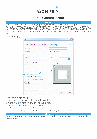
Printing a Mounting Template
NOTICE
It is not recommended that you print a mounting template on your own. Use the template that came in the product box.
If you do print the template, you must follow these instructions for printing a mounting template precisely. To print large templates,
you need large enough paper and printer. Failure to have the correct sized paper and printer, or a failure to follow these instructions,
may result in an incorrectly sized template and therefore an incorrect cutout (too large or too small) on the mounting surface of your
boat.
1
Select File > Print.
➋
➌
➍
➎
➊
2
Select None for Page Scaling ➊.
3
Ensure the check mark is next to Auto-Rotate and Center ➋.
4
Drag the arrow ➌ to the right, to view page 2 in the window below.
4
Verify that the paper size is larger than the template ➍.
In this example, the paper is not larger than the template.
5
If the paper size is not large enough, select Properties ➎ and select a Page Size that is larger than the template.
NOTICE
Garmin is not responsible for any damages or expenses resulting from a miscut mounting surface arising from a failure to follow
these instructions.
Посмотреть инструкция для Garmin ECHOMAP UHD 92sv бесплатно. Руководство относится к категории навигаторы, 1 человек(а) дали ему среднюю оценку 9.3. Руководство доступно на следующих языках: английский. У вас есть вопрос о Garmin ECHOMAP UHD 92sv или вам нужна помощь? Задайте свой вопрос здесь
Главная
| Garmin | |
| ECHOMAP UHD 92sv | |
| навигатор | |
| английский | |
| Инструкция/сборка (PDF), Правила техники безопасности (PDF) |
Технические характеристики
| Номинальная RMS-мощность | 500 W |
| Датчик температуры воды | Да |
| Цастота | 70 kHz |
| Подсветка | Да |
| Максимальная глубина | — m |
Экран
| Дисплей | — |
| Разрешение экрана | 400 x 800 пикселей |
| Диагональ экрана | 9 « |
| Размер дисплея (ГхВ) | 199 x 113 mm |
Вес и размеры
| Размеры (ШхГхВ) | 263 x 165 x 65 mm |
| Вес | 1000 g |
Условия эксплуатации
| Водонепроницаемый | Да |
| International Protection (IP) код | IPX7 |
показать больше
Не можете найти ответ на свой вопрос в руководстве? Вы можете найти ответ на свой вопрос ниже, в разделе часто задаваемых вопросов о Garmin ECHOMAP UHD 92sv.
Какой вес Garmin ECHOMAP UHD 92sv?
Garmin ECHOMAP UHD 92sv имеет вес 1000 g.
Необходим ли интернет для GPS?
Нет, для использования GPS не требуется интернет.
Что означает аббревиатура GPS?
Аббревиатура GPS расшифровывается как Global Positioning System, т. е. система глобального позиционирования.
Что такое GPS?
GPS — это система, которая может использоваться в любой точке мира для определения вашего местоположения с помощью спутников.
Можно ли обновить карты моей навигационной системы?
Большинство навигационных систем поддерживают обновление карт. Большинство брендов периодически обновляют карты.
Какой размер экрана Garmin ECHOMAP UHD 92sv?
Размер экрана Garmin ECHOMAP UHD 92sv составляет 9 «.
Какое разрешение экрана дисплея Garmin ECHOMAP UHD 92sv?
Разрешение экрана Garmin ECHOMAP UHD 92sv следующее 400 x 800 пикселей.
Инструкция Garmin ECHOMAP UHD 92sv доступно в русский?
Да, руководствоGarmin ECHOMAP UHD 92sv доступно врусский .
Не нашли свой вопрос? Задайте свой вопрос здесь