- Manuals
- Brands
- Garmin Manuals
- GPS
- aera 795
Manuals and User Guides for Garmin aera 795. We have 5 Garmin aera 795 manuals available for free PDF download: Pilot’s Manual, Quick Reference Manual, Specifications
Garmin aera 795 Pilot’s Manual (252 pages)
Brand: Garmin
|
Category: GPS
|
Size: 7.07 MB
Table of Contents
-
Table of Contents
13
-
Section 1 Overview
17
-
Unit Overview
17
-
Getting Started
18
-
Battery Installation
18
-
Charging the Battery
19
-
Mounting the Aera 795/796 in the Aircraft
20
-
Turning the Unit On/Off
20
-
GPS Receiver Status
22
-
Acquiring Satellites
23
-
Satellite Information
23
-
-
Display Orientation
24
-
-
Operation
24
-
Basic Touchscreen Operation
24
-
Dedicated Icons
26
-
Page Buttons (Optional)
26
-
Main Menu
27
-
-
Menus and Data Entry
31
-
Option Menus
31
-
Data Entry
31
-
-
Using Map Displays
34
-
Map Range
34
-
Auto Zoom
35
-
Map Panning
36
-
Map Overlays
38
-
Map Symbols
38
-
-
System Settings
39
-
Display
40
-
Sound
42
-
Additional Settings
43
-
-
Nearest Airport Criteria Settings
44
-
Present Position
45
-
Position
45
-
New Location
45
-
Simulator Mode
46
-
-
-
Section 2 Gps Navigation
47
-
Introduction
47
-
Data Fields
48
-
Gps Navigation
49
-
Data Field Options
50
-
-
Numeric Flight Data
51
-
Compass Arc
52
-
-
Hsi/Panel
53
-
Setting the Bug Indicator
54
-
Manually Setting a Course
54
-
Vertical Navigation (VNAV)
55
-
Using the VNAV Feature
56
-
-
-
Table of Contents
58
-
Map Display Setup
58
-
Map Orientation
59
-
Airports, Navaids, Cities & Roads
59
-
Airways
60
-
-
Waypoints
61
-
Waypoint Information
62
-
Waypoint Frequencies
64
-
Waypoint Weather and NOTAM Information
64
-
Airport Directory Waypoint Information
65
-
Viewing Chart Information by Identifier
66
-
Nearest Information
66
-
Textual Weather and NOTAM Information
69
-
Accessing Additional Information
71
-
Creating User Waypoints
74
-
Deleting User Waypoints
75
-
Select a City
76
-
-
-
Direct-To Navigation
80
-
-
Section 3 Flight Planning
83
-
Introduction
83
-
Data Fields
84
-
-
Flight Plan Creation
85
-
Flight Planning
86
-
Adding Waypoints to an Existing Flight Plan
87
-
Graphical Flight Planning
87
-
-
Flight Plan Storage
90
-
Flight Plan Activation
90
-
Flight Plan Editing
91
-
Editing Speed and Fuel Flow
91
-
Copying Flight Plans
92
-
Deleting Flight Plans
92
-
Inverting a Flight Plan
93
-
Importing/Exporting Flight Plans
94
-
-
Approaches
94
-
Selecting an Approach
95
-
-
-
Section 4 Hazard Avoidance
99
-
Weather
99
-
Sxm
100
-
Hazard Avoidance
100
-
Winds Aloft
104
-
Storm Cells
105
-
Freezing Level
110
-
-
Using S Irius XM Satellite Weather Products
113
-
Data Link Weather (FIS-B) (795 and 796)
117
-
Nexrad Abnormalities
120
-
Using FIS-B Weather Products
128
-
-
Terrain
132
-
Terrain Information
133
-
Obstacle Information
133
-
Terrain and Obstacle Color Code
134
-
Terrain Views
134
-
Terrain Alerts & Setup
135
-
-
Traffic
138
-
Traffic Information Service (TIS-A)
139
-
Traffic Warning Window
140
-
Data Link Traffic (GDL 39)
142
-
System Status
145
-
Traffic Description
146
-
Symbol Description
146
-
-
-
-
Section 5 Additional Features
155
-
Vision
156
-
Vision Operation
157
-
-
Airport Directory Data
159
-
Chartview
161
-
Aircraft Symbol
163
-
Chart Range
164
-
Jeppesen Database-Published Notams
164
-
-
Flitecharts
165
-
Aircraft Symbol
168
-
Flitechart Range
169
-
Flitecharts Cycle Number and Expiration Date
169
-
-
VFR/IFR Chart Viewing
170
-
Safetaxi
171
-
Safetaxi Cycle Number and Revision
172
-
-
Siriusxm ® Radio (Aera 796)
172
-
Activating Siriusxm Satellite Radio Services
173
-
Using Siriusxm Radio
174
-
-
Electronic Checklists
178
-
-
Section 6 Appendices
179
-
Appendix A: Messages, Alerts & Data Field Options
179
-
Miscellaneous Message Advisories
179
-
Airspace Messages
181
-
Data Field & Numeric Data Options
181
-
Aural Alerts
183
-
-
Appendix B: Abnormal Operation
185
-
Loss of GPS Position
185
-
Hazard Display with Loss of GPS Position
185
-
-
Appendix C: SD Cards and Databases
186
-
SD Card Use
186
-
Databases
187
-
-
Appendix D: Installation and Interfacing
193
-
Mounting the Aera 795/796 in the Aircraft
193
-
Connecting to a Computer
197
-
Interfacing
198
-
Connecting to a Garmin VHF Comm Radio
200
-
Connecting the GXM 40 Antenna (Aera 796)
202
-
Connecting to a GTX 330 Mode S Transponder
203
-
-
-
Table of Contents
204
-
Connecting to a GDL 39
204
-
Using an External GPS Antenna (Optional)
205
-
-
Appendix E: Battery and Care Information
207
-
Battery Information
207
-
Changing the Cigarette Lighter Adapter Fuse
207
-
Cleaning the Casing
208
-
Cleaning the Touchscreen
208
-
Protecting the Unit
208
-
-
Appendix F: General TIS-A Information
209
-
TIS-A Vs. TAS/TCAS
209
-
TIS-A Limitations
209
-
-
Appendix G: Utilities
213
-
Document Viewer
213
-
Scratch Pad
213
-
Flight Log
214
-
Track Log
216
-
Heading Line
219
-
E6B Calculator
220
-
Aircraft Profile
222
-
Weight & Balance
224
-
Proximity Waypoints
226
-
-
Appendix H: Display Symbols
229
-
VFR Symbols
229
-
IFR Symbols
230
-
Airspace Symbols
232
-
-
Appendix I: Map Datum and Location Formats
235
-
Map Datums
235
-
Location Formats
235
-
-
Appendix J: Glossary
237
-
Appendix K: License Agreement and Warranty
243
-
Contact Garmin
243
-
Software License Agreement
243
-
Limited Warranty
243
-
AOPA Airport Directory Notice
244
-
Ac-U-Kwik License Agreement
244
-
S Irius XM Satellite Radio Service Agreement
245
-
Weather Data Warranty
245
-
FCC Compliance
246
-
Industry Canada Compliance
246
-
Index
247
-
Advertisement

Garmin aera 795 Pilot’s Manual (210 pages)
Brand: Garmin
|
Category: GPS
|
Size: 6.2 MB
Table of Contents
-
Table of Contents
11
-
Section 1 Overview
15
-
Unit Overview
15
-
Getting Started
16
-
Battery Installation
16
-
Charging the Battery
17
-
Mounting the Aera 795/796 in the Aircraft
18
-
Turning the Unit On/Off
19
-
GPS Receiver Status
20
-
Acquiring Satellites
21
-
Satellite Information
21
-
-
Display Orientation
22
-
-
Operation
22
-
Basic Touchscreen Operation
22
-
Dedicated Icons
24
-
Page Buttons (Optional)
24
-
Main Menu
25
-
-
Menus and Data Entry
29
-
Option Menus
29
-
Data Entry
29
-
-
Using Map Displays
32
-
Map Range
32
-
Auto Zoom
33
-
Map Panning
34
-
Map Overlays
36
-
Map Symbols
36
-
-
System Settings
37
-
Display
38
-
Sound
40
-
Additional Settings
41
-
-
Nearest Airport Criteria Settings
42
-
Present Position
42
-
Position
42
-
New Location
43
-
Simulator Mode
43
-
-
-
Section 2 GPS Navigation
45
-
Introduction
45
-
Data Fields
46
-
Gps Navigation
47
-
Data Field Options
48
-
-
Numeric Flight Data
49
-
Compass Arc
50
-
-
Hsi/Panel
51
-
Setting the Bug Indicator
52
-
Manually Setting a Course
52
-
Vertical Navigation (VNAV)
53
-
Using the VNAV Feature
54
-
-
-
Table of Contents
56
-
Map Display Setup
56
-
Map Orientation
57
-
Airports, Navaids, Cities & Roads
57
-
Airways
58
-
-
Waypoints
58
-
Waypoint Information
59
-
Waypoint Frequencies
61
-
Waypoint Weather Information
62
-
Airport Directory Waypoint Information
62
-
Viewing Chart Information by Identifier
63
-
Nearest Information
64
-
Textual Weather Information
66
-
Accessing Additional Information
68
-
Creating User Waypoints
71
-
Deleting User Waypoints
72
-
Select a City
73
-
-
-
Direct-To Navigation
77
-
-
Section 3 Flight Planning
79
-
Introduction
79
-
Data Fields
80
-
-
Flight Plan Creation
81
-
Flight Planning
82
-
Adding Waypoints to an Existing Flight Plan
83
-
-
Flight Plan Storage
84
-
Flight Plan Activation
84
-
Flight Plan Editing
85
-
Editing Speed and Fuel Flow
85
-
Copying Flight Plans
86
-
Deleting Flight Plans
86
-
Inverting a Flight Plan
87
-
Importing/Exporting Flight Plans
88
-
-
Approaches
88
-
Selecting an Approach
89
-
Activating Vectors-To-Final
91
-
-
-
Section 4 Hazard Avoidance
93
-
Sxm
93
-
Activating Services
93
-
S Irius XM Satellite Weather Products
94
-
Hazard Avoidance
95
-
Winds Aloft
97
-
Storm Cells
98
-
Freezing Levels
103
-
Surface Pressure
105
-
-
Using S Irius XM Satellite Weather Products
106
-
-
Terrain
109
-
Terrain Information
110
-
Obstacle Information
110
-
Terrain and Obstacle Color Code
111
-
Terrain Views
112
-
Terrain Alerts & Setup
113
-
-
Traffic Information Service (TIS)
115
-
TIS Symbology
115
-
TIS Alerts
116
-
Traffic Ground Track
117
-
Displaying Traffic Data
117
-
-
-
Section 5 Additional Features
119
-
Vision
120
-
Vision Operation
121
-
Additional Features
122
-
-
Airport Directory Data
123
-
Chartview
125
-
Aircraft Symbol
126
-
Chart Range
127
-
Jeppesen Database-Published Notams
127
-
-
Flitecharts
128
-
Aircraft Symbol
130
-
Flitechart Range
130
-
Flitecharts Cycle Number and Expiration Date
131
-
-
VFR/IFR Chart Viewing
131
-
Safetaxi
132
-
Safetaxi Cycle Number and Revision
133
-
-
Siriusxm ® Radio (Aera 796)
133
-
Activating Siriusxm Satellite Radio Services
134
-
Using Siriusxm Radio
135
-
Using Favorites
137
-
Adjusting the Volume
139
-
-
-
Electronic Checklists
140
-
-
Section 6 Appendices
141
-
Appendix A: Messages, Alerts & Data Field Options
141
-
Miscellaneous Message Advisories
141
-
Airspace Messages
143
-
Data Field & Numeric Data Options
143
-
Aural Alerts
145
-
-
Appendix B: Abnormal Operation
147
-
Loss of GPS Position
147
-
Hazard Display with Loss of GPS Position
147
-
-
Appendix C: SD Cards and Databases
148
-
SD Card Use
148
-
Databases
149
-
-
Appendix D: Installation and Interfacing
153
-
Mounting the Aera 795/796 in the Aircraft
153
-
Connecting to a Computer
157
-
-
-
Table of Contents
158
-
Connecting to a Garmin VHF Comm Radio
158
-
Connecting the GXM 40 Antenna (Aera 796)
160
-
Connecting to a GTX 330 Mode S Transponder
161
-
Interfacing
161
-
Using an External GPS Antenna (Optional)
163
-
-
Appendix E: Battery and Care Information
165
-
Battery Information
165
-
Changing the Cigarette Lighter Adapter Fuse
165
-
Cleaning the Casing
166
-
Cleaning the Touchscreen
166
-
Protecting the Unit
166
-
-
Appendix F: General TIS Information
167
-
TIS Vs. TAS/TCAS
167
-
TIS Limitations
167
-
-
Appendix G: Utilities
171
-
Document Viewer
171
-
Scratch Pad
171
-
Flight Log
172
-
Track Log
174
-
Heading Line
177
-
E6B Calculator
178
-
Aircraft Profile
180
-
Weight & Balance
182
-
Proximity Waypoints
184
-
-
Appendix H: Display Symbols
187
-
VFR Symbols
187
-
IFR Symbols
188
-
Airspace Symbols
190
-
-
Appendix I: Map Datum and Location Formats
193
-
Map Datums
193
-
Location Formats
193
-
-
Appendix J: Glossary
195
-
Appendix K: License Agreement and Warranty
201
-
Contact Garmin
201
-
Software License Agreement
201
-
Limited Warranty
201
-
AOPA Airport Directory Notice
202
-
S Irius XM Satellite Radio Service Agreement
202
-
Weather Data Warranty
203
-
FCC Compliance
204
-
Industry Canada Compliance
204
-
Garmin aera 795 Quick Reference Manual (70 pages)
Brand: Garmin
|
Category: GPS
|
Size: 1.65 MB
Table of Contents
-
Table of Contents
7
-
Section 1 Overview
9
-
Unit Overview
9
-
Getting Started
10
-
Battery Installation
10
-
Charging the Battery
12
-
GPS Receiver Status
12
-
Display Orientation
12
-
-
Operation
13
-
Basic Touchscreen Operation
13
-
Dedicated Icons
15
-
Page Buttons (Optional)
15
-
Main Menu
16
-
-
Menus and Data Entry
20
-
Option Menus
20
-
Data Entry
20
-
-
Using Map Displays
22
-
Map Range
22
-
Map Panning
23
-
Panning the Map
24
-
Map Overlays
26
-
Bluetooth
26
-
-
-
Section 2 Gps Navigation
27
-
Flight Data
27
-
Data Fields
27
-
Numeric Flight Data
27
-
-
Hsi/Panel
28
-
Setting the Bug Indicator
28
-
Manually Setting a Course
28
-
-
Vertical Navigation (VNAV)
29
-
Using the VNAV Feature
29
-
-
Waypoints
30
-
Nearest Information
31
-
Textual Weather and NOTAM Information
31
-
Gps Navigation
32
-
User Waypoints
33
-
-
Direct-To Navigation
33
-
-
Section 3 Flight Planning
35
-
Flight Plan Data Fields
35
-
Flight Plan Creation
35
-
Flight Planning
36
-
Adding Flight Plan Waypoints
37
-
Graphical Flight Planning
37
-
-
Flight Plan Storage
40
-
-
Table of Contents
40
-
Flight Plan Activation
40
-
Flight Plan Deletion
41
-
Approaches
41
-
-
Section 4 Hazard Avoidance
45
-
Weather
45
-
Siriusxm Weather (Aera 796 Only)
45
-
Data Link Weather (FIS-B) (795 and 796)
45
-
Hazard Avoidance
46
-
-
Terrain
47
-
Traffic
47
-
Traffic Information Service (TIS-A)
48
-
Data Link Traffic (GDL 39)
48
-
System Status
49
-
-
-
Section 5 Utilities
53
-
Flight Log
53
-
Track Log
53
-
E6B Calculator
54
-
Aircraft Profile
55
-
Weight & Balance
56
-
-
Section 6 Appendix
57
-
Miscellaneous Message Advisories
57
-
Airspace Messages
58
-
Data Field & Numeric Data Options
59
-
Aural Alerts
61
-
Loss of GPS Position
61
-
Hazard Display with Loss of GPS Position
62
-
License Agreement and Warranty
62
-
AOPA Airport Directory Notice
63
-
Ac-U-Kwik License Agreement
64
-
S Irius XM Satellite Radio Service Agreement
64
-
Weather Data Warranty
64
-
FCC Compliance
66
-
Industry Canada Compliance
66
-
-
Index
67
Advertisement
Garmin aera 795 Quick Reference Manual (60 pages)
Brand: Garmin
|
Category: GPS
|
Size: 1.09 MB
Table of Contents
-
Table of Contents
9
-
Section 1 Overview
11
-
Unit Overview
11
-
Getting Started
12
-
Battery Installation
12
-
Charging the Battery
14
-
GPS Receiver Status
14
-
Display Orientation
14
-
-
Operation
15
-
Dedicated Icons
15
-
Page Buttons
15
-
Main Menu
16
-
Basic Touchscreen Operation
20
-
-
Menus and Data Entry
21
-
Option Menus
21
-
Data Entry
22
-
-
Using Map Displays
23
-
Map Panning
23
-
Map Range
25
-
Map Overlays
25
-
-
-
Section 2 GPS Navigation
27
-
Flight Data
27
-
Data Fields
27
-
Numeric Flight Data
27
-
-
Hsi/Panel
28
-
Setting the Bug Indicator
28
-
Manually Setting a Course
28
-
-
Vertical Navigation (Vnav)
29
-
Using the VNAV Feature
29
-
-
Waypoints
30
-
Nearest Information
31
-
Weather Information (Aera 796)
31
-
User Waypoints
31
-
-
Direct-To Navigation
32
-
Gps Navigation
33
-
-
-
Section 3 Flight Planning
35
-
Flight Plan Data Fields
35
-
Flight Plan Creation
35
-
Adding Flight Plan Waypoints
36
-
Flight Plan Storage
37
-
Flight Plan Activation
38
-
Flight Plan Deletion
38
-
Approaches
39
-
Flight Planning
40
-
-
-
Table of Contents
41
-
Section 4 Hazard Avoidance
41
-
S Irius XM ® Weather (Aera 796)
41
-
Terrain
41
-
Traffic Information Service (Tis)
42
-
-
Section 5 Utilities
43
-
Flight Log
43
-
Track Log
43
-
E6B Calculator
44
-
Aircraft Profile
45
-
Weight & Balance
46
-
-
Section 6 Appendix
47
-
Miscellaneous Message Advisories
47
-
Airspace Messages
48
-
Data Field & Numeric Data Options
49
-
Aural Alerts
51
-
Loss of GPS Position
51
-
Hazard Display with Loss of GPS Position
51
-
License Agreement and Warranty
52
-
AOPA Airport Directory Notice
53
-
S Irius XM Satellite Radio Service Agreement
54
-
Weather Data Warranty
54
-
FCC Compliance
55
-
Industry Canada Compliance
55
-

Garmin aera 795 Specifications (2 pages)
area portable touchscreen GPS
Brand: Garmin
|
Category: GPS
|
Size: 0.59 MB
Advertisement
Related Products
-
Garmin aera 500
-
Garmin aera 550
-
Garmin aera 510
-
Garmin aera 1900111700
-
Garmin aera 190-01117-02
-
Garmin aera 560
-
Garmin aera 796
-
Garmin AERA 660
-
Garmin Aera 760
-
Garmin Approach S1 North America
Garmin Categories
![]()
GPS
Watch
Car Navigation system
Avionics Display
Marine GPS System
More Garmin Manuals

- 1
- 2
- 3
- 4
- 5
- 6
- 7
- 8
- 9
- 10
- 11
- 12
- 13
- 14
- 15
- 16
- 17
- 18
- 19
- 20
- 21
- 22
- 23
- 24
- 25
- 26
- 27
- 28
- 29
- 30
- 31
- 32
- 33
- 34
- 35
- 36
- 37
- 38
- 39
- 40
- 41
- 42
- 43
- 44
- 45
- 46
- 47
- 48
- 49
- 50
- 51
- 52
- 53
- 54
- 55
- 56
- 57
- 58
- 59
- 60
- 61
- 62
- 63
- 64
- 65
- 66
- 67
- 68
- 69
- 70
- 71
- 72
- 73
- 74
- 75
- 76
- 77
- 78
- 79
- 80
- 81
- 82
- 83
- 84
- 85
- 86
- 87
- 88
- 89
- 90
- 91
- 92
- 93
- 94
- 95
- 96
- 97
- 98
- 99
- 100
- 101
- 102
- 103
- 104
- 105
- 106
- 107
- 108
- 109
- 110
- 111
- 112
- 113
- 114
- 115
- 116
- 117
- 118
- 119
- 120
- 121
- 122
- 123
- 124
- 125
- 126
- 127
- 128
- 129
- 130
- 131
- 132
- 133
- 134
- 135
- 136
- 137
- 138
- 139
- 140
- 141
- 142
- 143
- 144
- 145
- 146
- 147
- 148
- 149
- 150
- 151
- 152
- 153
- 154
- 155
- 156
- 157
- 158
- 159
- 160
- 161
- 162
- 163
- 164
- 165
- 166
- 167
- 168
- 169
- 170
- 171
- 172
- 173
- 174
- 175
- 176
- 177
- 178
- 179
- 180
- 181
- 182
- 183
- 184
- 185
- 186
- 187
- 188
- 189
- 190
- 191
- 192
- 193
- 194
- 195
- 196
- 197
- 198
- 199
- 200
- 201
- 202
- 203
- 204
- 205
- 206
- 207
- 208
- 209
- 210
- 211
- 212
- 213
- 214
- 215
- 216
- 217
- 218
- 219
- 220
- 221
- 222
- 223
- 224
- 225
- 226
- 227
- 228
- 229
- 230
- 231
- 232
- 233
- 234
- 235
- 236
- 237
- 238
- 239
- 240
- 241
- 242
- 243
- 244
- 245
- 246
- 247
- 248
- 249
- 250
- 251
- 252
- 253
Посмотреть инструкция для Garmin Camper 795 бесплатно. Руководство относится к категории навигаторы, 2 человек(а) дали ему среднюю оценку 9.6. Руководство доступно на следующих языках: русский. У вас есть вопрос о Garmin Camper 795 или вам нужна помощь? Задайте свой вопрос здесь
Не можете найти ответ на свой вопрос в руководстве? Вы можете найти ответ на свой вопрос ниже, в разделе часто задаваемых вопросов о Garmin Camper 795.
Какой вес Garmin Camper 795?
Garmin Camper 795 имеет вес 239.6 g.
Необходим ли интернет для GPS?
Нет, для использования GPS не требуется интернет.
Что означает аббревиатура GPS?
Аббревиатура GPS расшифровывается как Global Positioning System, т. е. система глобального позиционирования.
Что такое GPS?
GPS — это система, которая может использоваться в любой точке мира для определения вашего местоположения с помощью спутников.
Можно ли обновить карты моей навигационной системы?
Большинство навигационных систем поддерживают обновление карт. Большинство брендов периодически обновляют карты.
Какой размер экрана Garmin Camper 795?
Размер экрана Garmin Camper 795 составляет 6.95 «.
Какая высота Garmin Camper 795?
Garmin Camper 795 имеет высоту 99 mm.
Какое разрешение экрана дисплея Garmin Camper 795?
Разрешение экрана Garmin Camper 795 следующее 1024 x 600 пикселей.
Какая ширина Garmin Camper 795?
Garmin Camper 795 имеет ширину 173 mm.
Какая толщина Garmin Camper 795?
Garmin Camper 795 имеет толщину 19 mm.
Какой объем памяти Garmin Camper 795 имеет?
Garmin Camper 795 имеет 32 GB объем памяти.
Инструкция Garmin Camper 795 доступно в русский?
Да, руководствоGarmin Camper 795 доступно врусский .
Не нашли свой вопрос? Задайте свой вопрос здесь
-
Страница 1
models: 795 and 796 ™ Pilot’s Guide[…]
-
Страница 2
[…]
-
Страница 3
OVER VIEW GPS NA VIGA TION FLIGHT PLANNING HAZARD A VOID ANCE ADDITIONAL FEA TURES APPENDICES INDEX[…]
-
Страница 4
[…]
-
Страница 5
Copyright © 2011-2012 Garmin Ltd. or its subsidiaries. All rights reserved. T his manual reflects the oper ation of System Software version 3.10 or later . Some differences in operation may be observed when comparing the information in this manual to earlier or later software versions . Garmin International, Inc., 1200 East 151st Street, Olathe ,[…]
-
Страница 6
Garmin aera 795/796 Pilot’ s Guide 190-01194-00 Rev . C W arnings, Cautions & Notes W ARNING: Navigation and terrain separation must NO T be predicated upon the use of the terrain function. T he aera 795/796 T errain Proximity feature is NO T intended to be used as a primary reference for terrain avoidance and does not relieve the pilot from […]
-
Страница 7
Garmin aera 795/796 Pilot’ s Guide 190-01194-00 Rev . C W arnings, Cautions & Notes W ARNING: T o reduce the risk of unsafe operation, carefully review and understand all aspects of the aera 795/796 Pilot’ s Guide documentation and the Pilot’ s Operating Handbook of the aircraft. T horoughly practice basic operation prior to actual use . […]
-
Страница 8
Garmin aera 795/796 Pilot’ s Guide 190-01194-00 Rev . C W arnings, Cautions & Notes B A TTER Y WARNINGS: If these guidelines are not followed, the internal lithium-ion battery may experience a shortened life span or may present a risk of damage to the GPS device , fire, chemical burn, electrolyte leak, and/or injury . • Do not leave the[…]
-
Страница 9
Garmin aera 795/796 Pilot’ s Guide 190-01194-00 Rev . C W arnings, Cautions & Notes CA UTION: T he Garmin aera 795/796 does not contain any user -serviceable parts . Repairs should only be made by an authorized Garmin service center . Unauthorized repairs or modifications could void both the warranty and the pilot’ s authority to operate t[…]
-
Страница 10
Garmin aera 795/796 Pilot’ s Guide 190-01194-00 Rev . C Blank P age[…]
-
Страница 11
Garmin aera 795/796 Pilot’ s Guide 190-01194-00 Rev . C RR-11 Part Number Change Summary 190-01194-00 Initial release Rev Date Description A August, 2011 Production Release B August, 2012 Added GDL 39 Support C September , 2012 Added T argetT rend™ Support[…]
-
Страница 12
Garmin aera 795/796 Pilot’ s Guide 190-01194-00 Rev . C RR-12 Blank P age[…]
-
Страница 13
Garmin aera 795/796 Pilot’ s Guide 190-01194-00 Rev . C i T able of Contents SECTION 1 OVER VIEW ………………………………………………………………………………………………… 1 1.1 Unit Overview …………………………………………………………………………………………………….. 1 […]
-
Страница 14
Garmin aera 795/796 Pilot’ s Guide 190-01194-00 Rev . C ii T able of Contents 2.4 Map Display Setup ……………………………………………………………………………………………. 42 Map Orientation………………………………………………………………………………………………….. 43 Airpor[…]
-
Страница 15
Garmin aera 795/796 Pilot’ s Guide 190-01194-00 Rev . C iii T able of Contents 4.3 T raffic ……………………………………………………………………………………………………………… 122 T r affic Information Service (TIS-A) ………………………………………………………………………….[…]
-
Страница 16
Garmin aera 795/796 Pilot’ s Guide 190-01194-00 Rev . C iv T able of Contents Connecting to a GDL 39 ……………………………………………………………………………………… 188 Using an external GPS Antenna (Optional) ……………………………………………………………… 189 Appendix E: Battery and C[…]
-
Страница 17
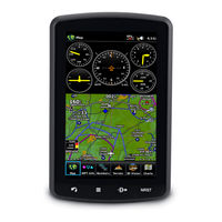
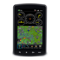
Garmin aera 795/796 Pilot’ s Guide 190-01194-00 Rev . C 1 Overview Overview GPS Navigation Flight Planning Hazard A voidance Additional Features Appendices Index SECTION 1 O VERVIEW 1.1 UNIT O VERVIEW T he aera 795/796 presents GPS-derived analog flight instrumentation, position, navigation, and hazard avoidance information to the pilot using a […]
-
Страница 18
Garmin aera 795/796 Pilot’ s Guide 190-01194-00 Rev . C 2 Overview Overview GPS Navigation Flight Planning Hazard A voidance Additional Features Appendices Index SD Car d Slot Unit Overview (Right Side) Power Button 1.2 GETTING ST ARTED B A TTER Y INST ALLA TION NO TE : Refer to Appendix E for additional battery information. CA UTION: Always k ee[…]
-
Страница 19
Garmin aera 795/796 Pilot’ s Guide 190-01194-00 Rev . C 3 Overview Overview GPS Navigation Flight Planning Hazard A voidance Additional Features Appendices Index Battery Release: Push to r emove the battery Unit Overview (Back — Battery Out) Power Button SD Car d Slot Battery Contacts CHARGING THE BA TTERY NO TE : While in Charge Mode the unit dr[…]
-
Страница 20
Garmin aera 795/796 Pilot’ s Guide 190-01194-00 Rev . C 4 Overview Overview GPS Navigation Flight Planning Hazard A voidance Additional Features Appendices Index Charge the aera 795/796 for at least 4 hours before using on battery power . Charge the battery by connecting the aviation power cable or the AC adapter . Plug the unit into a 12-V olt o[…]
-
Страница 21
Garmin aera 795/796 Pilot’ s Guide 190-01194-00 Rev . C 5 Overview Overview GPS Navigation Flight Planning Hazard A voidance Additional Features Appendices Index T he power button can be used to quickly set the backlight intensity . A momentary press of the power button (after the unit is powered on) will display a window showing the current back[…]
-
Страница 22
Garmin aera 795/796 Pilot’ s Guide 190-01194-00 Rev . C 6 Overview Overview GPS Navigation Flight Planning Hazard A voidance Additional Features Appendices Index GPS RECEIVER ST A TUS T he receiver status displays one of the following conditions: • AutoLocate—Receiver is looking for any satellite whose almanac has been collected, which can[…]
-
Страница 23
Garmin aera 795/796 Pilot’ s Guide 190-01194-00 Rev . C 7 Overview Overview GPS Navigation Flight Planning Hazard A voidance Additional Features Appendices Index Viewing the GPS status: F rom the Main Menu , touch T ools > GPS Status . A CQUIRING SA TELLITES T he bars located at the top of the screen indicate the GPS signal strength. When the […]
-
Страница 24
Garmin aera 795/796 Pilot’ s Guide 190-01194-00 Rev . C 8 Overview Overview GPS Navigation Flight Planning Hazard A voidance Additional Features Appendices Index DISPLA Y ORIENT A TION T he aera 795/796 can be viewed in either P ortrait or Landscape Mode . Changing the display orientation: 1) F rom the Main Menu , touch T ools > Setup > Dis[…]
-
Страница 25
Garmin aera 795/796 Pilot’ s Guide 190-01194-00 Rev . C 9 Overview Overview GPS Navigation Flight Planning Hazard A voidance Additional Features Appendices Index SCROLLING AND P ANNING Scrolling and panning on the touchscreen: Drag up or down to scroll menus , documents , etc. Or: Drag in any direction to pan maps or charts . Scrolling P anning Z[…]
-
Страница 26
Garmin aera 795/796 Pilot’ s Guide 190-01194-00 Rev . C 10 Overview Overview GPS Navigation Flight Planning Hazard A voidance Additional Features Appendices Index DEDICA TED ICONS Located on the bezel (below the touchscreen) are four dedicated touch icons . T ouch or touch and hold the following icons to perform the associated function: Dedicated[…]
-
Страница 27
Garmin aera 795/796 Pilot’ s Guide 190-01194-00 Rev . C 11 Overview Overview GPS Navigation Flight Planning Hazard A voidance Additional Features Appendices Index 3) F rom the current P age Buttons along the bottom of the screen, touch the P age Button that will be replaced by the new page button. The current P age Button is now replaced by the n[…]
-
Страница 28
Garmin aera 795/796 Pilot’ s Guide 190-01194-00 Rev . C 12 Overview Overview GPS Navigation Flight Planning Hazard A voidance Additional Features Appendices Index NEAREST ICONS T ouch the icon at any time to access the second-level Nearest icons . T ouch the following icons to display the associated function: Airport Displays nearest airports . A[…]
-
Страница 29
Garmin aera 795/796 Pilot’ s Guide 190-01194-00 Rev . C 13 Overview Overview GPS Navigation Flight Planning Hazard A voidance Additional Features Appendices Index MET AR Displays MET ARs . (XM or GDL 39). AIRMET Displays AIRMETs . (XM or GDL 39). SIGMET Displays SIGMETs . (XM or GDL 39). TFR Displays TFRs (XM or GDL 39). PIREP Displays PIREPs . ([…]
-
Страница 30
Garmin aera 795/796 Pilot’ s Guide 190-01194-00 Rev . C 14 Overview Overview GPS Navigation Flight Planning Hazard A voidance Additional Features Appendices Index P osition Displays the aircraft’s Present P osition. Checklists Displays the checklists if available . Scratchpad Displays the scr atchpad. GPS Status Displays GPS status informati[…]
-
Страница 31
Garmin aera 795/796 Pilot’ s Guide 190-01194-00 Rev . C 15 Overview Overview GPS Navigation Flight Planning Hazard A voidance Additional Features Appendices Index 1.4 MENUS AND D A T A ENTR Y OPTION MENUS T he aera 795/796 has a dedicated Icon that displays a context-sensitive list of menu options available . Navigating the option menu: ➊ T ouc[…]
-
Страница 32
Garmin aera 795/796 Pilot’ s Guide 190-01194-00 Rev . C 16 Overview Overview GPS Navigation Flight Planning Hazard A voidance Additional Features Appendices Index Entering alphanumeric data: ➊ W hen alphanumeric data can be entered, a k eypad will appear after touching the desired datafield. ➋ T ouch the k eypad to enter the desired data. ?[…]
-
Страница 33
Garmin aera 795/796 Pilot’ s Guide 190-01194-00 Rev . C 17 Overview Overview GPS Navigation Flight Planning Hazard A voidance Additional Features Appendices Index Entering predetermined data options: ➊ T ouch the Data Option Button to display a vertical list of data options (if applicable), or to toggle two data options (i.e ., On/Off) . Or : T[…]
-
Страница 34
Garmin aera 795/796 Pilot’ s Guide 190-01194-00 Rev . C 18 Overview Overview GPS Navigation Flight Planning Hazard A voidance Additional Features Appendices Index 1.5 USING MAP DISPLA Y S NO TE : Refer to the GPS Navigation section for more information on Map Display Setup . Map displays are used extensively in the aera 795/796 to provide situati[…]
-
Страница 35
Garmin aera 795/796 Pilot’ s Guide 190-01194-00 Rev . C 19 Overview Overview GPS Navigation Flight Planning Hazard A voidance Additional Features Appendices Index Or : Pi nch fingers together (zoom out), or pull fingers apart (zoom in). Zoom Out Zoom In O VERZOOM When the selected range exceeds the resolution of the map data, ‘overzoom’ app[…]
-
Страница 36
Garmin aera 795/796 Pilot’ s Guide 190-01194-00 Rev . C 20 Overview Overview GPS Navigation Flight Planning Hazard A voidance Additional Features Appendices Index MAP P ANNING Map panning allows the pilot to: • V iew parts of the map outside the displayed range without adjusting the map range • Hig[…]
-
Страница 37
Garmin aera 795/796 Pilot’ s Guide 190-01194-00 Rev . C 21 Overview Overview GPS Navigation Flight Planning Hazard A voidance Additional Features Appendices Index Activating the map pointer: While viewing a Map Display , touch anywhere on the map to activ ate the map pointer . T ouch the icon to cancel the map pointer . P anning the map: While vi[…]
-
Страница 38
Garmin aera 795/796 Pilot’ s Guide 190-01194-00 Rev . C 22 Overview Overview GPS Navigation Flight Planning Hazard A voidance Additional Features Appendices Index MAP O VERLA YS T he ➊ Weather , ➋ T opography , and ➌ T errain map overlays can be displayed or removed. ➊ ➋ ➌ Displaying/removing map overlays: 1) F rom the Main Menu , tou[…]
-
Страница 39
Garmin aera 795/796 Pilot’ s Guide 190-01194-00 Rev . C 23 Overview Overview GPS Navigation Flight Planning Hazard A voidance Additional Features Appendices Index MAP DET AIL T he map detail can also be adjusted. Map detail changes the amount of detail with respect to the zoom scale . Adjusting the map detail: 1) F rom the Main Menu , touch Map &[…]
-
Страница 40
Garmin aera 795/796 Pilot’ s Guide 190-01194-00 Rev . C 24 Overview Overview GPS Navigation Flight Planning Hazard A voidance Additional Features Appendices Index DISPLA Y NO TE : Display Setup can also be accessed through the ‘Quick Settings’ by pressing the POWER Button once quickly . T wo quick presses of the POWER Button will change[…]
-
Страница 41
Garmin aera 795/796 Pilot’ s Guide 190-01194-00 Rev . C 25 Overview Overview GPS Navigation Flight Planning Hazard A voidance Additional Features Appendices Index B A CKLIGHT TIMEOUT After a specified period of inactivity the backlight will turn off to save battery power . Adjusting backlight timeout: 1) F rom the Main Menu , touch T ools > S[…]
-
Страница 42
Garmin aera 795/796 Pilot’ s Guide 190-01194-00 Rev . C 26 Overview Overview GPS Navigation Flight Planning Hazard A voidance Additional Features Appendices Index AIRCRAFT POSITION ON MAP/CHAR TS Displaying/removing the aircr aft position on maps/charts: 1) F rom the Main Menu , touch T ools > Setup > Display . 2) T ouch the ‘Aircr aft[…]
-
Страница 43
Garmin aera 795/796 Pilot’ s Guide 190-01194-00 Rev . C 27 Overview Overview GPS Navigation Flight Planning Hazard A voidance Additional Features Appendices Index ADDITIONAL SETTINGS Changing settings ( Display , Sound , Units , Date & Time , Map, P osition , Interface , Bluetooth, etc . ) : 1) F rom the Main Menu , touch T ools > Setup . […]
-
Страница 44
Garmin aera 795/796 Pilot’ s Guide 190-01194-00 Rev . C 28 Overview Overview GPS Navigation Flight Planning Hazard A voidance Additional Features Appendices Index 1.7 NEAREST AIRPORT CRITERIA SETTINGS T he Nearest Airports function allows the pilot to filter out airports that do not meet a defined criteria. Specific surface types and runway le[…]
-
Страница 45
Garmin aera 795/796 Pilot’ s Guide 190-01194-00 Rev . C 29 Overview Overview GPS Navigation Flight Planning Hazard A voidance Additional Features Appendices Index 1.8 PRESENT POSITION POSITION T he Present Position function displays latitude , longitude, GPS altitude , reference waypoint, type , distance , direction, and bearing. T he reference w[…]
-
Страница 46
Garmin aera 795/796 Pilot’ s Guide 190-01194-00 Rev . C 30 Overview Overview GPS Navigation Flight Planning Hazard A voidance Additional Features Appendices Index SIMULA T OR MODE Simulator Mode is helpful for pr acticing with the unit indoors or when satellite or XM signals are unavailable . All waypoints and routes created in Simulator Mode are[…]
-
Страница 47
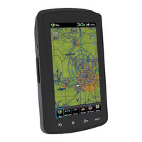
Garmin aera 795/796 Pilot’ s Guide 190-01194-00 Rev . C 31 GPS Navigation Overview GPS Navigation Flight Planning Hazard A voidance Additional Features Appendices Index SECTION 2 GPS NA VIGA TION 2.1 INTRODUCTION T he Navigation Map displays aviation data (e.g., airports , V ORs, airways , airspaces), geographic data (e .g., cities, lak es, highw[…]
-
Страница 48
Garmin aera 795/796 Pilot’ s Guide 190-01194-00 Rev . C 32 GPS Navigation Overview GPS Navigation Flight Planning Hazard A voidance Additional Features Appendices Index D A T A FIELDS T he data fields on the Navigation Map can be independently configured by the user . Data Fields (Navigation Map) Data Fields By default, the Data Fields are set […]
-
Страница 49
Garmin aera 795/796 Pilot’ s Guide 190-01194-00 Rev . C 33 GPS Navigation Overview GPS Navigation Flight Planning Hazard A voidance Additional Features Appendices Index Changing the information shown in the data fields: ➊ F rom the Main Menu , touch the Map Icon. ➋ T ouch the Menu Icon. ➌ To uch the ‘ Change Data Fields ‘ menu op[…]
-
Страница 50
Garmin aera 795/796 Pilot’ s Guide 190-01194-00 Rev . C 34 GPS Navigation Overview GPS Navigation Flight Planning Hazard A voidance Additional Features Appendices Index D A T A FIELD OPTIONS • Accur acy • Altitude • Bearing(BRG) • CoursetoSteer(CTS) • Desired T rack(DTK) • Distance(Destination)?[…]
-
Страница 51
Garmin aera 795/796 Pilot’ s Guide 190-01194-00 Rev . C 35 GPS Navigation Overview GPS Navigation Flight Planning Hazard A voidance Additional Features Appendices Index NUMERIC FLIGHT D A T A T he numeric flight data can be independently configured by the user . NO TE : For units that support XM and have a GDL 39, the ‘Numbers’ icon i[…]
-
Страница 52
Garmin aera 795/796 Pilot’ s Guide 190-01194-00 Rev . C 36 GPS Navigation Overview GPS Navigation Flight Planning Hazard A voidance Additional Features Appendices Index COMP ASS ARC A compass arc appears by default on the Navigation Map . T he route line represents the course and the magenta bug indicator (similar to the bug indicator on the HSI)[…]
-
Страница 53
Garmin aera 795/796 Pilot’ s Guide 190-01194-00 Rev . C 37 GPS Navigation Overview GPS Navigation Flight Planning Hazard A voidance Additional Features Appendices Index 2.2 HSI/P ANEL T he HSI/Panel shows GPS-derived data in a graphical format. K eep in mind the differences between the GPS-derived panel and mechanical instruments , as mechanical […]
-
Страница 54
Garmin aera 795/796 Pilot’ s Guide 190-01194-00 Rev . C 38 GPS Navigation Overview GPS Navigation Flight Planning Hazard A voidance Additional Features Appendices Index T he course deviation scale appears on the lower right corner of the HSI. T here are four CDI Scale settings (‘Automatic’, ‘0.25 nm’, ‘1.25 nm’, and […]
-
Страница 55
Garmin aera 795/796 Pilot’ s Guide 190-01194-00 Rev . C 39 GPS Navigation Overview GPS Navigation Flight Planning Hazard A voidance Additional Features Appendices Index 4) T ouch the ‘ + ‘ or ‘ — ‘ Buttons to increase/decrease the v alue Or : T ouch the Radial Button to enter the desired r adial using the k eypad and touch the[…]
-
Страница 56
Garmin aera 795/796 Pilot’ s Guide 190-01194-00 Rev . C 40 GPS Navigation Overview GPS Navigation Flight Planning Hazard A voidance Additional Features Appendices Index At 500 ft above the target altitude , the “ Approaching T arget Altitude” message appears , the ‘Estimated T ime To VNA V’ goes blank, and the VNA V indicator disappears f[…]
-
Страница 57
Garmin aera 795/796 Pilot’ s Guide 190-01194-00 Rev . C 41 GPS Navigation Overview GPS Navigation Flight Planning Hazard A voidance Additional Features Appendices Index V ertical Navigation • W aypoint—Enter any waypoint along the currently active route as the reference waypoint. T he reference waypoint defines the target location. •[…]
-
Страница 58
Garmin aera 795/796 Pilot’ s Guide 190-01194-00 Rev . C 42 GPS Navigation Overview GPS Navigation Flight Planning Hazard A voidance Additional Features Appendices Index 4) T ouch the ‘ Capture VNA V Profile ‘ or ‘ Cancel Capture ‘ menu option (only available when navigating a Direct T o or Flight Plan). VNA V Indicator (P ane[…]
-
Страница 59
Garmin aera 795/796 Pilot’ s Guide 190-01194-00 Rev . C 43 GPS Navigation Overview GPS Navigation Flight Planning Hazard A voidance Additional Features Appendices Index MAP ORIENT A TION Maps are shown in one of three different orientation options , allowing flexibility in determining aircraft position relative to other items on the map (North U[…]
-
Страница 60
Garmin aera 795/796 Pilot’ s Guide 190-01194-00 Rev . C 44 GPS Navigation Overview GPS Navigation Flight Planning Hazard A voidance Additional Features Appendices Index 3) T ouch the buttons to select the desired settings (if av ailable), or touch the Data Option Button to select from a list of options . Map Setup (Airport) Medium T ext Large T e[…]
-
Страница 61
Garmin aera 795/796 Pilot’ s Guide 190-01194-00 Rev . C 45 GPS Navigation Overview GPS Navigation Flight Planning Hazard A voidance Additional Features Appendices Index are called “flight levels” and are described as FL450 for 45,000 feet MSL). Jet Routes are designated with a “J” before the route number . Low Altitude Airways are dr awn[…]
-
Страница 62
Garmin aera 795/796 Pilot’ s Guide 190-01194-00 Rev . C 46 GPS Navigation Overview GPS Navigation Flight Planning Hazard A voidance Additional Features Appendices Index W aypoint Information (Info T ab) W aypoint Identifier Button Info T ab Bearing/ Distance -W aypoint Identifier T ype -Fuel A vailable -Elevation -Region -Time Zone (UTC Of fset[…]
-
Страница 63
Garmin aera 795/796 Pilot’ s Guide 190-01194-00 Rev . C 47 GPS Navigation Overview GPS Navigation Flight Planning Hazard A voidance Additional Features Appendices Index 3) Enter the desired waypoint: a) T ouch the buttons to display the desired search option on the ‘Search’ Button (‘ Search by Identifier ‘ , ‘ Sear ch by[…]
-
Страница 64
Garmin aera 795/796 Pilot’ s Guide 190-01194-00 Rev . C 48 GPS Navigation Overview GPS Navigation Flight Planning Hazard A voidance Additional Features Appendices Index 4) T ouch the desired Runw ay Button. T he map range zooms in and centers on the desired runway . T ouch the Runway Button again to return to the previous map range . W A YPOINT F[…]
-
Страница 65
Garmin aera 795/796 Pilot’ s Guide 190-01194-00 Rev . C 49 GPS Navigation Overview GPS Navigation Flight Planning Hazard A voidance Additional Features Appendices Index a) T ouch the buttons to display the desired search option on the ‘Search’ Button (‘ Search by Identifier ‘ , ‘ Sear ch by F acility Name ‘ , ‘[…]
-
Страница 66
Garmin aera 795/796 Pilot’ s Guide 190-01194-00 Rev . C 50 GPS Navigation Overview GPS Navigation Flight Planning Hazard A voidance Additional Features Appendices Index b) T ouch the desired w aypoint from the list. 3) T ouch the A OP A or Dir ectory Ta b . VIEWING CHART INFORMA TION BY IDENTIFIER Viewing Chart information: 1) F rom the Main Menu[…]
-
Страница 67
Garmin aera 795/796 Pilot’ s Guide 190-01194-00 Rev . C 51 GPS Navigation Overview GPS Navigation Flight Planning Hazard A voidance Additional Features Appendices Index • Airport WX (Airport Weather) —identifier , bearing, distance, MET AR text (aera 796 only), and A TIS, AWOS , or ASOS frequency . • VOR (VHF Omnidirectional Radio Be[…]
-
Страница 68
Garmin aera 795/796 Pilot’ s Guide 190-01194-00 Rev . C 52 GPS Navigation Overview GPS Navigation Flight Planning Hazard A voidance Additional Features Appendices Index Nearest Airports List Additional Airport Information NEAREST AIRPOR T CRITERIA T he pilot can define the minimum runway length and surface type used when determining the 15 neare[…]
-
Страница 69
Garmin aera 795/796 Pilot’ s Guide 190-01194-00 Rev . C 53 GPS Navigation Overview GPS Navigation Flight Planning Hazard A voidance Additional Features Appendices Index TEXTU AL WEA THER AND NOT AM INFORMA TION T extual weather information can be viewed several different w ays. NO T AMs for the weather tab are only available with a GDL 39. Viewin[…]
-
Страница 70
Garmin aera 795/796 Pilot’ s Guide 190-01194-00 Rev . C 54 GPS Navigation Overview GPS Navigation Flight Planning Hazard A voidance Additional Features Appendices Index 3) T ouch the Map F eature Button with the desired identifier displayed (refer to ‘Map P anning’ in the Overview Section for more information). The weather information […]
-
Страница 71
Garmin aera 795/796 Pilot’ s Guide 190-01194-00 Rev . C 55 GPS Navigation Overview GPS Navigation Flight Planning Hazard A voidance Additional Features Appendices Index A CCESSING ADDITIONAL INFORMA TION In addition to airport and weather information, additional information for VORs , NDBs , Intersections , User Waypoints , Cities, AR TCCs , FSSs[…]
-
Страница 72
Garmin aera 795/796 Pilot’ s Guide 190-01194-00 Rev . C 56 GPS Navigation Overview GPS Navigation Flight Planning Hazard A voidance Additional Features Appendices Index INTERSECTIONS Intersection information can be viewed using the W aypoint Information function, the Nearest function, or the Map Panning function. T he Nearest Intersection functio[…]
-
Страница 73
Garmin aera 795/796 Pilot’ s Guide 190-01194-00 Rev . C 57 GPS Navigation Overview GPS Navigation Flight Planning Hazard A voidance Additional Features Appendices Index 1) Touch NRST > NDB . 2) T ouch the desired Nearest NDB from the list. The NDB information is displayed. 3) If desired, touch Menu > Show Map or Show Chart . Or : 1) F rom t[…]
-
Страница 74
Garmin aera 795/796 Pilot’ s Guide 190-01194-00 Rev . C 58 GPS Navigation Overview GPS Navigation Flight Planning Hazard A voidance Additional Features Appendices Index 3) T ouch the Map F eature Button with the desired VOR displayed (refer to the Overview Section on ‘Map P anning’ for more information). The V OR information is displaye[…]
-
Страница 75
Garmin aera 795/796 Pilot’ s Guide 190-01194-00 Rev . C 59 GPS Navigation Overview GPS Navigation Flight Planning Hazard A voidance Additional Features Appendices Index Editing or renaming a user waypoint: 1) F rom the Main Menu , touch T ools > User WPT . 2) T ouch the desired User W aypoint. 3) T ouch Menu . 4) T ouch the ‘ Edit W aypoi[…]
-
Страница 76
Garmin aera 795/796 Pilot’ s Guide 190-01194-00 Rev . C 60 GPS Navigation Overview GPS Navigation Flight Planning Hazard A voidance Additional Features Appendices Index d) If desired, touch the ‘ Less Than / More Than ‘ Button, and touch the Distance Field to enter the desired distance . e) T ouch the OK icon. The confirmation window w[…]
-
Страница 77
Garmin aera 795/796 Pilot’ s Guide 190-01194-00 Rev . C 61 GPS Navigation Overview GPS Navigation Flight Planning Hazard A voidance Additional Features Appendices Index FSS FSS information can be viewed using the Nearest function. T he Nearest FSS function can be used to quickly find a FSS close to the flight path. T he list only includes FSS t[…]
-
Страница 78
Garmin aera 795/796 Pilot’ s Guide 190-01194-00 Rev . C 62 GPS Navigation Overview GPS Navigation Flight Planning Hazard A voidance Additional Features Appendices Index Nearest Airspace A IrSp A ce A ler t M eSSAgeS If airspace alarms are set to ‘On’ (default is ‘Off’), the aera 795/796 will display a message which includes th[…]
-
Страница 79
Garmin aera 795/796 Pilot’ s Guide 190-01194-00 Rev . C 63 GPS Navigation Overview GPS Navigation Flight Planning Hazard A voidance Additional Features Appendices Index Airspace alert setup: 1) F rom the Main Menu , touch T ools > Setup > SU A Alarms . 2) Touch the desired On / Off Button(s). Airspace Alert Message S MArt A IrSp Ace ™ Sma[…]
-
Страница 80
Garmin aera 795/796 Pilot’ s Guide 190-01194-00 Rev . C 64 GPS Navigation Overview GPS Navigation Flight Planning Hazard A voidance Additional Features Appendices Index 2.6 DIRECT -TO NA VIGA TION T he Direct-to method of navigation, initiated by pressing the Direct T o Icon is quick er to use than a flight plan when the desire is to navigate to[…]
-
Страница 81
Garmin aera 795/796 Pilot’ s Guide 190-01194-00 Rev . C 65 GPS Navigation Overview GPS Navigation Flight Planning Hazard A voidance Additional Features Appendices Index b) Enter the desired Identifier , F acility Name , or City using the k eypad. Refer to the Overview Section on ‘Data Entry’ for more information. c) T ouch the OK Icon.[…]
-
Страница 82
Garmin aera 795/796 Pilot’ s Guide 190-01194-00 Rev . C 66 GPS Navigation Overview GPS Navigation Flight Planning Hazard A voidance Additional Features Appendices Index Blank P age[…]
-
Страница 83
Garmin aera 795/796 Pilot’ s Guide 190-01194-00 Rev . C 67 Flight Planning Overview GPS Navigation Flight Planning Hazard A voidance Additional Features Appendices Index SECTION 3 FLIGHT PLANNING 3.1 INTRODUCTION Flight planning on the aera 795/796 consists of building a flight plan by entering waypoints one at a time and inserting approaches as[…]
-
Страница 84
Garmin aera 795/796 Pilot’ s Guide 190-01194-00 Rev . C 68 Flight Planning Overview GPS Navigation Flight Planning Hazard A voidance Additional Features Appendices Index D A T A FIELDS T he Active and Saved Flight Plan Data Fields can be changed by touching the Data Field Buttons at the top of the flight plan. Changing the information shown in t[…]
-
Страница 85
Garmin aera 795/796 Pilot’ s Guide 190-01194-00 Rev . C 69 Flight Planning Overview GPS Navigation Flight Planning Hazard A voidance Additional Features Appendices Index 3.2 FLIGHT PLAN CREA TION T he active flight plan is the flight plan to which the aera 795/796 is currently providing guidance , and is shown on the navigation maps . Stored ?[…]
-
Страница 86
Garmin aera 795/796 Pilot’ s Guide 190-01194-00 Rev . C 70 Flight Planning Overview GPS Navigation Flight Planning Hazard A voidance Additional Features Appendices Index b) T ouch the ‘Search’ Button (between the ). c) Enter the desired data using the k eypad. If duplicate entries are displayed, touch the desired duplicate from the list[…]
-
Страница 87
Garmin aera 795/796 Pilot’ s Guide 190-01194-00 Rev . C 71 Flight Planning Overview GPS Navigation Flight Planning Hazard A voidance Additional Features Appendices Index ADDING W A YPOINTS TO AN EXISTING FLIGHT PLAN W aypoints can be added to the active flight plan or any stored flight plan. Choose the flight plan, select the desired point of […]
-
Страница 88
Garmin aera 795/796 Pilot’ s Guide 190-01194-00 Rev . C 72 Flight Planning Overview GPS Navigation Flight Planning Hazard A voidance Additional Features Appendices Index 2) T ouch the ‘ T ouch to add W aypoint ‘ Button. 3) Enter the departure point by: a) T ouching the buttons to display the desired search option on the ‘Search&apo[…]
-
Страница 89
Garmin aera 795/796 Pilot’ s Guide 190-01194-00 Rev . C 73 Flight Planning Overview GPS Navigation Flight Planning Hazard A voidance Additional Features Appendices Index 2) T ouch an existing flight plan leg to edit. When an existing flight plan leg is selected, it will be highlighted in light blue . T ouch a new location on the map to split th[…]
-
Страница 90
Garmin aera 795/796 Pilot’ s Guide 190-01194-00 Rev . C 74 Flight Planning Overview GPS Navigation Flight Planning Hazard A voidance Additional Features Appendices Index 3.3 FLIGHT PLAN ST ORA GE T he aera 795/796 can store up to 50 flight plans . T he active flight plan is erased when another flight plan is activated. Details about each store[…]
-
Страница 91
Garmin aera 795/796 Pilot’ s Guide 190-01194-00 Rev . C 75 Flight Planning Overview GPS Navigation Flight Planning Hazard A voidance Additional Features Appendices Index 3) T ouch Direct-to twice . T he «Activate Leg XXXXX-XXXXX?» window is displayed 4) T ouch Ye s to activate . T o cancel, touch No or Back. 3.5 FLIGHT PLAN EDITING EDIT[…]
-
Страница 92
Garmin aera 795/796 Pilot’ s Guide 190-01194-00 Rev . C 76 Flight Planning Overview GPS Navigation Flight Planning Hazard A voidance Additional Features Appendices Index COPYING FLIGHT PLANS T he aera 795/796 allows copying a flight plan into a new flight plan memory slot, allowing editing, etc., without affecting the original flight plan. T h[…]
-
Страница 93
Garmin aera 795/796 Pilot’ s Guide 190-01194-00 Rev . C 77 Flight Planning Overview GPS Navigation Flight Planning Hazard A voidance Additional Features Appendices Index Deleting an individual waypoint from a saved flight plan: 1) F rom the Main Menu , touch FPL List. 2) T ouch the desired saved flight plan. The saved flight plan is displayed.[…]
-
Страница 94
Garmin aera 795/796 Pilot’ s Guide 190-01194-00 Rev . C 78 Flight Planning Overview GPS Navigation Flight Planning Hazard A voidance Additional Features Appendices Index IMPORTING/EXPORTING FLIGHT PLANS Importing flight plans: 1) Insert an SD Card containing one or more flight plans into the SD Card Slot. 2) F rom the Main Menu , touch FPL List[…]
-
Страница 95
Garmin aera 795/796 Pilot’ s Guide 190-01194-00 Rev . C 79 Flight Planning Overview GPS Navigation Flight Planning Hazard A voidance Additional Features Appendices Index Approach Selection T ouch to Change Airport T ouch to select Appr oach Appr oach Action Options SELECTING AN APPRO ACH When selecting an approach, it replaces the destination air[…]
-
Страница 96
Garmin aera 795/796 Pilot’ s Guide 190-01194-00 Rev . C 80 Flight Planning Overview GPS Navigation Flight Planning Hazard A voidance Additional Features Appendices Index 2) With the flight plan displayed, touch the Menu Icon. 3) T ouch the ‘ Select Approach ‘ menu option (only av ailable if the destination airport has a published appro[…]
-
Страница 97
Garmin aera 795/796 Pilot’ s Guide 190-01194-00 Rev . C 81 Flight Planning Overview GPS Navigation Flight Planning Hazard A voidance Additional Features Appendices Index Or: T ouch Activate V ectors-to-Final , the aera 795/796 creates an extension of the final course , beyond the final approach w aypoint in the database (final approach fix [F[…]
-
Страница 98
Garmin aera 795/796 Pilot’ s Guide 190-01194-00 Rev . C 82 Flight Planning Overview GPS Navigation Flight Planning Hazard A voidance Additional Features Appendices Index Blank P age[…]
-
Страница 99
Garmin aera 795/796 Pilot’ s Guide 190-01194-00 Rev . C 83 Hazard A voidance Overview GPS Navigation Flight Planning Hazard A voidance Additional Features Appendices Index SECTION 4 HAZARD A VOID ANCE 4.1 WEA THER WEA THER SOURCE With a SiriusXM subscription (aera 796 only) and FIS-B weather information (through GDL 39), there are three options a[…]
-
Страница 100
Garmin aera 795/796 Pilot’ s Guide 190-01194-00 Rev . C 84 Hazard A voidance Overview GPS Navigation Flight Planning Hazard A voidance Additional Features Appendices Index S irius XM ® WEA THER ( aer a 796 ONL Y) NOTE: Y ou MUST have a GXM 40 smart antenna connected to your aera 796 and a subscription to SiriusXM Weather to use SiriusXM Weather […]
-
Страница 101
Garmin aera 795/796 Pilot’ s Guide 190-01194-00 Rev . C 85 Hazard A voidance Overview GPS Navigation Flight Planning Hazard A voidance Additional Features Appendices Index Accessing the SiriusXM Radio ID Radio ID S IrIuS XM SA TELLITE WEA THER PRODUCTS NEXRAD NEXRAD (NEXt-generation RADar), is a network of multiple high-resolution Doppler radar s[…]
-
Страница 102
Garmin aera 795/796 Pilot’ s Guide 190-01194-00 Rev . C 86 Hazard A voidance Overview GPS Navigation Flight Planning Hazard A voidance Additional Features Appendices Index NEXRAD data is not real-time . T he lapsed time between collection, processing, and dissemination of NEXRAD images can be significant and may not reflect the current radar sy[…]
-
Страница 103
Garmin aera 795/796 Pilot’ s Guide 190-01194-00 Rev . C 87 Hazard A voidance Overview GPS Navigation Flight Planning Hazard A voidance Additional Features Appendices Index • NEXRAD base reectivity issampled atthe minimumantenna elevation angle . An individual NEXRAD site cannot depict high altitude[…]
-
Страница 104
Garmin aera 795/796 Pilot’ s Guide 190-01194-00 Rev . C 88 Hazard A voidance Overview GPS Navigation Flight Planning Hazard A voidance Additional Features Appendices Index ECHO T OPS Echo T ops are derived from NEXRAD radar and indicate the highest altitude at which precipitation is falling. Echo Tops at or above the altitude you select are displ[…]
-
Страница 105
Garmin aera 795/796 Pilot’ s Guide 190-01194-00 Rev . C 89 Hazard A voidance Overview GPS Navigation Flight Planning Hazard A voidance Additional Features Appendices Index Winds Barbs Wind Dir ection Calm 5 kts 10 kts 15 kts 20 kts 50 kts Wind Flag Winds Str eamlines S IrIuS XM LIGHTNING Lightning data shows the approximate location of cloud-to-g[…]
-
Страница 106
Garmin aera 795/796 Pilot’ s Guide 190-01194-00 Rev . C 90 Hazard A voidance Overview GPS Navigation Flight Planning Hazard A voidance Additional Features Appendices Index Storm Cell Data (Map) Additional Storm Cell Information MET ARS AND T AFS NOTE: MET AR information is only displayed within the installed aviation database service area. MET AR[…]
-
Страница 107
Garmin aera 795/796 Pilot’ s Guide 190-01194-00 Rev . C 91 Hazard A voidance Overview GPS Navigation Flight Planning Hazard A voidance Additional Features Appendices Index Map Featur e Button Additional MET AR Data MET AR Data (Map) MET AR Selected with Map Pointer T he MET AR flag color is determined by the information in the MET AR text. VFR ([…]
-
Страница 108
Garmin aera 795/796 Pilot’ s Guide 190-01194-00 Rev . C 92 Hazard A voidance Overview GPS Navigation Flight Planning Hazard A voidance Additional Features Appendices Index AIRMETS An AIRMET (AIRmen’ s MET eorological Information) can be especially helpful for pilots of light aircraft that have limited flight capability or instrumentation. An A[…]
-
Страница 109
Garmin aera 795/796 Pilot’ s Guide 190-01194-00 Rev . C 93 Hazard A voidance Overview GPS Navigation Flight Planning Hazard A voidance Additional Features Appendices Index TEMPORAR Y FLIGHT RESTRICTIONS (TFR) NO TE: Do not rely solely upon data link services to provide T emporary Flight Restriction TFR information. Always confirm TFR information[…]
-
Страница 110
Garmin aera 795/796 Pilot’ s Guide 190-01194-00 Rev . C 94 Hazard A voidance Overview GPS Navigation Flight Planning Hazard A voidance Additional Features Appendices Index FREEZING LEVEL F reezing Level shows contours for the lowest forecast altitude where icing conditions are lik ely to occur . Freezing Level Data TURBULENCE FORECAST T urbulence[…]
-
Страница 111
Garmin aera 795/796 Pilot’ s Guide 190-01194-00 Rev . C 95 Hazard A voidance Overview GPS Navigation Flight Planning Hazard A voidance Additional Features Appendices Index Icing F orecast Legend Extreme Icing Selected With Map P ointer FORECAST F orecast information is available for current and forecast weather conditions . F orecasts are availab[…]
-
Страница 112
Garmin aera 795/796 Pilot’ s Guide 190-01194-00 Rev . C 96 Hazard A voidance Overview GPS Navigation Flight Planning Hazard A voidance Additional Features Appendices Index SURF A CE PRESSURE T his feature displays pressure isobars and pressure centers. T he isobars connect points of equal pressure . Pressure readings can help determine weather an[…]
-
Страница 113
Garmin aera 795/796 Pilot’ s Guide 190-01194-00 Rev . C 97 Hazard A voidance Overview GPS Navigation Flight Planning Hazard A voidance Additional Features Appendices Index USING S irius XM SA TELLITE WEA THER PRODUCTS W ARNING: Do not use data link weather information for maneuvering in, near , or around areas of hazardous weather . Information c[…]
-
Страница 114
Garmin aera 795/796 Pilot’ s Guide 190-01194-00 Rev . C 98 Hazard A voidance Overview GPS Navigation Flight Planning Hazard A voidance Additional Features Appendices Index Viewing SiriusXM W eather products on the Navigation Map: 1) F rom the Main Menu touch the Map Icon. 2) T ouch the Menu Icon. 3) T ouch the ‘ Show/Hide … ‘ menu opt[…]
-
Страница 115
Garmin aera 795/796 Pilot’ s Guide 190-01194-00 Rev . C 99 Hazard A voidance Overview GPS Navigation Flight Planning Hazard A voidance Additional Features Appendices Index Setting up and customizing weather data for the Navigation Map: 1) F rom the Main Menu touch the Map Icon. 2) T ouch the Menu Icon. 3) T ouch the ‘ Set Up Map ‘ menu […]
-
Страница 116
Garmin aera 795/796 Pilot’ s Guide 190-01194-00 Rev . C 100 Hazard A voidance Overview GPS Navigation Flight Planning Hazard A voidance Additional Features Appendices Index Viewing legends for displayed weather pr oducts: 1) F rom the Main Menu , touch the Map Icon. Or: a) F rom the ‘ Home ’ Screen, touch the W eather Icon. b) T ouch the desi[…]
-
Страница 117
Garmin aera 795/796 Pilot’ s Guide 190-01194-00 Rev . C 101 Hazard A voidance Overview GPS Navigation Flight Planning Hazard A voidance Additional Features Appendices Index D A T A LINK WEA THER (FIS-B) (795 AND 796) NOTE: T he Flight Information Service (FIS-B) weather data provides information for avoiding hazardous weather . Do not use FIS-B i[…]
-
Страница 118
Garmin aera 795/796 Pilot’ s Guide 190-01194-00 Rev . C 102 Hazard A voidance Overview GPS Navigation Flight Planning Hazard A voidance Additional Features Appendices Index Viewing Gr ound Station Status: 1) F rom the Main Menu touch the T ools Icon. 2) T ouch Data Link . 3) T ouch Menu > Ground Stations . Or: 1) F rom the Main Menu touch the […]
-
Страница 119
Garmin aera 795/796 Pilot’ s Guide 190-01194-00 Rev . C 103 Hazard A voidance Overview GPS Navigation Flight Planning Hazard A voidance Additional Features Appendices Index signals that may or may not contain new weather data. It does not represent the rate at which weather data is updated or new content is received by the GDL 39. FIS-B Products […]
-
Страница 120
Garmin aera 795/796 Pilot’ s Guide 190-01194-00 Rev . C 104 Hazard A voidance Overview GPS Navigation Flight Planning Hazard A voidance Additional Features Appendices Index NEXRAD data is not real-time . T he lapsed time between collection, processing, and dissemination of NEXRAD images can be significant and may not reflect the current radar s[…]
-
Страница 121
Garmin aera 795/796 Pilot’ s Guide 190-01194-00 Rev . C 105 Hazard A voidance Overview GPS Navigation Flight Planning Hazard A voidance Additional Features Appendices Index • NEXRAD base reectivity does not provide sufcient information to determine cloud layers or precipitation characteristics (hail vs . r[…]
-
Страница 122
Garmin aera 795/796 Pilot’ s Guide 190-01194-00 Rev . C 106 Hazard A voidance Overview GPS Navigation Flight Planning Hazard A voidance Additional Features Appendices Index FIS-B Radar Regional FIS-B Radar CONUS FIS-B Radar Combined[…]
-
Страница 123
Garmin aera 795/796 Pilot’ s Guide 190-01194-00 Rev . C 107 Hazard A voidance Overview GPS Navigation Flight Planning Hazard A voidance Additional Features Appendices Index WINDS ALOFT Winds Aloft data shows the forecasted wind speed and direction in 3,000-foot increments up to 39,000 feet MSL. T he wind barbs indicate wind speed and direction, a[…]
-
Страница 124
Garmin aera 795/796 Pilot’ s Guide 190-01194-00 Rev . C 108 Hazard A voidance Overview GPS Navigation Flight Planning Hazard A voidance Additional Features Appendices Index T emper atures Aloft MET ARS AND T AFS NOTE: MET AR information is only displayed within the installed aviation database service area. MET AR (MET eorological Aerodrome Report[…]
-
Страница 125
Garmin aera 795/796 Pilot’ s Guide 190-01194-00 Rev . C 109 Hazard A voidance Overview GPS Navigation Flight Planning Hazard A voidance Additional Features Appendices Index Map Featur e Button Additional MET AR Data MET AR Data (Map) MET AR Selected with Map Pointer T he MET AR flag color is determined by the information in the MET AR text. VFR […]
-
Страница 126
Garmin aera 795/796 Pilot’ s Guide 190-01194-00 Rev . C 110 Hazard A voidance Overview GPS Navigation Flight Planning Hazard A voidance Additional Features Appendices Index AIRMETS An AIRMET (AIRmen’ s MET eorological Information) can be especially helpful for pilots of light aircraft that have limited flight capability or instrumentation. An […]
-
Страница 127
Garmin aera 795/796 Pilot’ s Guide 190-01194-00 Rev . C 111 Hazard A voidance Overview GPS Navigation Flight Planning Hazard A voidance Additional Features Appendices Index TEMPORAR Y FLIGHT RESTRICTIONS (TFR) NO TE: Do not rely solely upon data link services to provide T emporary Flight Restriction TFR information. Always confirm TFR informatio[…]
-
Страница 128
Garmin aera 795/796 Pilot’ s Guide 190-01194-00 Rev . C 112 Hazard A voidance Overview GPS Navigation Flight Planning Hazard A voidance Additional Features Appendices Index USING FIS-B WEA THER PRODUCTS W ARNING: Do not use data link weather information for maneuvering in, near , or around areas of hazardous weather . Information contained within[…]
-
Страница 129
Garmin aera 795/796 Pilot’ s Guide 190-01194-00 Rev . C 113 Hazard A voidance Overview GPS Navigation Flight Planning Hazard A voidance Additional Features Appendices Index Viewing FIS-B W eather products on the Navigation Map: 1) F rom the Main Menu touch the Map Icon. 2) T ouch the Menu Icon. 3) T ouch the ‘ Show/Hide … ‘ menu optio[…]
-
Страница 130
Garmin aera 795/796 Pilot’ s Guide 190-01194-00 Rev . C 114 Hazard A voidance Overview GPS Navigation Flight Planning Hazard A voidance Additional Features Appendices Index Setting up and customizing weather data for the Navigation Map: 1) F rom the Main Menu touch the Map Icon. 2) T ouch the Menu Icon. 3) T ouch the ‘ Set Up Map ‘ menu[…]
-
Страница 131
Garmin aera 795/796 Pilot’ s Guide 190-01194-00 Rev . C 115 Hazard A voidance Overview GPS Navigation Flight Planning Hazard A voidance Additional Features Appendices Index Viewing legends for displayed weather pr oducts: 1) F rom the Main Menu , touch the Map Icon. Or: a) F rom the ‘ Home ’ Screen, touch the W eather Icon. b) T ouch the desi[…]
-
Страница 132
Garmin aera 795/796 Pilot’ s Guide 190-01194-00 Rev . C 116 Hazard A voidance Overview GPS Navigation Flight Planning Hazard A voidance Additional Features Appendices Index 4.2 TERRAIN WARNING: Do not use T errain information for primary terrain avoidance . T errain information is intended only to enhance situational aw areness . NOTE: T errain d[…]
-
Страница 133
Garmin aera 795/796 Pilot’ s Guide 190-01194-00 Rev . C 117 Hazard A voidance Overview GPS Navigation Flight Planning Hazard A voidance Additional Features Appendices Index TERRAIN INFORMA TION T wo views are displayed by the T errain function: the Map View , and the Profile View . T he areas of the terrain shaded red are predicted to be within […]
-
Страница 134
Garmin aera 795/796 Pilot’ s Guide 190-01194-00 Rev . C 118 Hazard A voidance Overview GPS Navigation Flight Planning Hazard A voidance Additional Features Appendices Index TERRAIN AND OBST A CLE COLOR CODE Red—terrain or obstacle is above or within 100 feet below the aircr aft. Y ellow—terrainorobstacleisbetweentheuser -de?[…]
-
Страница 135
Garmin aera 795/796 Pilot’ s Guide 190-01194-00 Rev . C 119 Hazard A voidance Overview GPS Navigation Flight Planning Hazard A voidance Additional Features Appendices Index T errain Pr ofile View T errain Legend Red T errain is above or within 100 ft below the air craft. Y ellow T errain is Between the User — defined Caution Elevation and 100 f[…]
-
Страница 136
Garmin aera 795/796 Pilot’ s Guide 190-01194-00 Rev . C 120 Hazard A voidance Overview GPS Navigation Flight Planning Hazard A voidance Additional Features Appendices Index • Look Ahead T ime —Determines the maximum time when an alert annunciation occurs . F or example , if 120 seconds is selected, the aera 795/796 provides an alert up to […]
-
Страница 137
Garmin aera 795/796 Pilot’ s Guide 190-01194-00 Rev . C 121 Hazard A voidance Overview GPS Navigation Flight Planning Hazard A voidance Additional Features Appendices Index a CA UTION or a WARNING alert severity level, or both. When an alert is issued, visual annunciations are displayed and aural alerts are simultaneously issued. When the aircraf[…]
-
Страница 138
Garmin aera 795/796 Pilot’ s Guide 190-01194-00 Rev . C 122 Hazard A voidance Overview GPS Navigation Flight Planning Hazard A voidance Additional Features Appendices Index 4.3 TRAFFIC TRAFFIC SOURCE T he aera 795/796 is compatible with two different traffic sources; TIS-A traffic via a Garmin Mode S T r ansponder (GTX 330), or ADS-B/TIS-B tr a[…]
-
Страница 139
Garmin aera 795/796 Pilot’ s Guide 190-01194-00 Rev . C 123 Hazard A voidance Overview GPS Navigation Flight Planning Hazard A voidance Additional Features Appendices Index TRAFFIC INFORMA TION SER VICE (TIS-A) NOTE: Refer to Appendix F for general information regarding TIS-A. Refer to Appendix D for configuration information. T he aera 795/796 […]
-
Страница 140
Garmin aera 795/796 Pilot’ s Guide 190-01194-00 Rev . C 124 Hazard A voidance Overview GPS Navigation Flight Planning Hazard A voidance Additional Features Appendices Index If the number of T r affic Advisories on the TIS-A display decreases and then increases, a new audio alert is sounded. The TIS-A audio alert is also gener ated whenever TIS-A[…]
-
Страница 141
Garmin aera 795/796 Pilot’ s Guide 190-01194-00 Rev . C 125 Hazard A voidance Overview GPS Navigation Flight Planning Hazard A voidance Additional Features Appendices Index DISPLA YING TRAFFIC D A T A TIS-A traffic can be displayed on the Navigation Map . Enabling/disabling traffic data on the Map P age: 1) F rom the Main Menu touch the Map Ico[…]
-
Страница 142
Garmin aera 795/796 Pilot’ s Guide 190-01194-00 Rev . C 126 Hazard A voidance Overview GPS Navigation Flight Planning Hazard A voidance Additional Features Appendices Index D A T A LINK TRAFFIC (GDL 39) T he GDL 39 is a Bluetooth ® enabled receive-only data link radio with on-board GPS , 978 MHz (Universal Access T ransceiver frequency band), an[…]
-
Страница 143
Garmin aera 795/796 Pilot’ s Guide 190-01194-00 Rev . C 127 Hazard A voidance Overview GPS Navigation Flight Planning Hazard A voidance Additional Features Appendices Index Out refers to the capability to transmit ADS-B information. ADS-B participating refers to the capability to both send and receive ADS-B information. Aircraft lacking either AD[…]
-
Страница 144
Garmin aera 795/796 Pilot’ s Guide 190-01194-00 Rev . C 128 Hazard A voidance Overview GPS Navigation Flight Planning Hazard A voidance Additional Features Appendices Index TIS-B traffic may be displayed with degraded positional accur acy . Aircraft without operating tr ansponders are invisible to TIS-B . Aircr aft operating outside of the A TC […]
-
Страница 145
Garmin aera 795/796 Pilot’ s Guide 190-01194-00 Rev . C 129 Hazard A voidance Overview GPS Navigation Flight Planning Hazard A voidance Additional Features Appendices Index SY STEM ST A TUS T he traffic system status is annunciated in the upper right corner of the Map P age, as well as the lower left corner of the dedicated T r affic Page . Sys[…]
-
Страница 146
Garmin aera 795/796 Pilot’ s Guide 190-01194-00 Rev . C 130 Hazard A voidance Overview GPS Navigation Flight Planning Hazard A voidance Additional Features Appendices Index Configuring the GDL 39 for a Pressurized or Non-Pressurized Aircraft: 1) F rom the Main Menu touch the T ools Icon. 2) F rom the T ools menu touch Data Link . 3) T ouch Menu […]
-
Страница 147
Garmin aera 795/796 Pilot’ s Guide 190-01194-00 Rev . C 131 Hazard A voidance Overview GPS Navigation Flight Planning Hazard A voidance Additional Features Appendices Index Directional airborne T raffic Advisory (T A) with track vector . P oints in the direction of the aircraft tr ack. Directional off-scale airborne T raffic Advisory (T A). P o[…]
-
Страница 148
Garmin aera 795/796 Pilot’ s Guide 190-01194-00 Rev . C 132 Hazard A voidance Overview GPS Navigation Flight Planning Hazard A voidance Additional Features Appendices Index TRAFFIC ALER TS (ADS-B TIS-B) A traffic audio alert is gener ated whenever the number of T raffic Advisories on the aera 795/796 display increases . Limiting T raffic Advis[…]
-
Страница 149
Garmin aera 795/796 Pilot’ s Guide 190-01194-00 Rev . C 133 Hazard A voidance Overview GPS Navigation Flight Planning Hazard A voidance Additional Features Appendices Index T raffic W arning Window Range Rings T r affic W arning Window (Navigation Map) DISPLA YING TRAFFIC D A T A T raffic is displayed by default on the Map P age and in the T r[…]
-
Страница 150
Garmin aera 795/796 Pilot’ s Guide 190-01194-00 Rev . C 134 Hazard A voidance Overview GPS Navigation Flight Planning Hazard A voidance Additional Features Appendices Index 4) T ouch the buttons to select the T raffic Category . 5) F or T r affic Symbol or T r affic Label, touch the buttons to select the desired settings (‘ Off ‘ , &[…]
-
Страница 151
Garmin aera 795/796 Pilot’ s Guide 190-01194-00 Rev . C 135 Hazard A voidance Overview GPS Navigation Flight Planning Hazard A voidance Additional Features Appendices Index DEDICA TED TRAFFIC P AGE (TRF) Altitude filter settings from the T r affic Page are carried to the Map P age . Viewing the T raffic P age: 1) F rom the Main Menu touch the […]
-
Страница 152
Garmin aera 795/796 Pilot’ s Guide 190-01194-00 Rev . C 136 Hazard A voidance Overview GPS Navigation Flight Planning Hazard A voidance Additional Features Appendices Index T r affic P age (GDL 39) T raffic Advisory T raffic Display Range Rings Altitude/ Operating Mode Pr oximity Advisory (P A), 800’ above, Climbing Surface T raffic W/ Flig[…]
-
Страница 153
Garmin aera 795/796 Pilot’ s Guide 190-01194-00 Rev . C 137 Hazard A voidance Overview GPS Navigation Flight Planning Hazard A voidance Additional Features Appendices Index T r agetT rend™ (GDL 39) Alerts Disabled T raffic Display Range Rings Altitude/ Operating Mode T raffic System Status Receiving Air -to-Air only T raffic’s Pr edicat[…]
-
Страница 154
Garmin aera 795/796 Pilot’ s Guide 190-01194-00 Rev . C 138 Hazard A voidance Overview GPS Navigation Flight Planning Hazard A voidance Additional Features Appendices Index Motion vector selection is made from the T r affic Page Menu by enabling/disabling T argetT rend. Absolute vectors are selected by default and are replaced when T argetT rend[…]
-
Страница 155
Garmin aera 795/796 Pilot’ s Guide 190-01194-00 Rev . C 139 Additional Featur es Overview GPS Navigation Flight Planning Hazard A voidance Additional Features Appendices Index SECTION 5 ADDITIONAL FEA TURES NOTE: With the availability of SafeT axi and FliteCharts in electronic form, it is still advisable to carry another source of charts on board[…]
-
Страница 156
Garmin aera 795/796 Pilot’ s Guide 190-01194-00 Rev . C 140 Additional Featur es Overview GPS Navigation Flight Planning Hazard A voidance Additional Features Appendices Index 5.1 3D VISION 3D Vision provides a three-dimensional view of terr ain features as seen from outside the aircraft. 3D Vision imagery shows the relev ant features in relation[…]
-
Страница 157
Garmin aera 795/796 Pilot’ s Guide 190-01194-00 Rev . C 141 Additional Featur es Overview GPS Navigation Flight Planning Hazard A voidance Additional Features Appendices Index 3D VISION OPERA TION 3D Vision is accessed from the Main Menu . Viewing 3D Vision: F rom the Main Menu , touch 3D Vision Show/Hide 3D Vision T apes: F rom the Main Menu , t[…]
-
Страница 158
Garmin aera 795/796 Pilot’ s Guide 190-01194-00 Rev . C 142 Additional Featur es Overview GPS Navigation Flight Planning Hazard A voidance Additional Features Appendices Index 3D Vision[…]
-
Страница 159
Garmin aera 795/796 Pilot’ s Guide 190-01194-00 Rev . C 143 Additional Featur es Overview GPS Navigation Flight Planning Hazard A voidance Additional Features Appendices Index 5.2 AIRPORT DIRECT OR Y D A T A T he Airport Directory contains airport statistics such as pattern altitudes, noise abatement information, FBO phone numbers, hours of opera[…]
-
Страница 160
Garmin aera 795/796 Pilot’ s Guide 190-01194-00 Rev . C 144 Additional Featur es Overview GPS Navigation Flight Planning Hazard A voidance Additional Features Appendices Index Airport Directory Data Airport Identifier Field Service Icon Icon Description Restaurant on Field Self Serve Fuel Courtesy Car Airport Directory Service Icons[…]
-
Страница 161
Garmin aera 795/796 Pilot’ s Guide 190-01194-00 Rev . C 145 Additional Featur es Overview GPS Navigation Flight Planning Hazard A voidance Additional Features Appendices Index 5.3 CHARTVIEW NOTE: Either ChartView or FliteCharts may be used at one time , but not both. ChartView resembles the paper version of Jeppesen terminal procedure charts . Th[…]
-
Страница 162
Garmin aera 795/796 Pilot’ s Guide 190-01194-00 Rev . C 146 Additional Featur es Overview GPS Navigation Flight Planning Hazard A voidance Additional Features Appendices Index Sample Chart Indicating Off-Scale Areas Off-Scale Ar ea Off-Scale Ar eas Displaying ChartView: 1) F rom the Main Menu , touch WPT Info > TERPs T ab (if necessary) . 2) T[…]
-
Страница 163
Garmin aera 795/796 Pilot’ s Guide 190-01194-00 Rev . C 147 Additional Featur es Overview GPS Navigation Flight Planning Hazard A voidance Additional Features Appendices Index a) T ouch the buttons to cycle through the w aypoint categories (‘ Flight Plan W aypoints ‘ , ‘ Nearest Airports’ , or ‘ Recent W aypoints ‘).[…]
-
Страница 164
Garmin aera 795/796 Pilot’ s Guide 190-01194-00 Rev . C 148 Additional Featur es Overview GPS Navigation Flight Planning Hazard A voidance Additional Features Appendices Index Aircraft Symbol Displayed on Chart (W aypoint P age) Single Display Air craft Position on Chart Aircraft Symbol Not Shown Icon (W aypoint P age) Air craft Symbol Not Shown […]
-
Страница 165
Garmin aera 795/796 Pilot’ s Guide 190-01194-00 Rev . C 149 Additional Featur es Overview GPS Navigation Flight Planning Hazard A voidance Additional Features Appendices Index 5.4 FLITECHARTS NOTE: Either ChartView or FliteCharts may be used at one time , but not both. FliteCharts resemble the paper version of National Aeronautical Charting Offi[…]
-
Страница 166
Garmin aera 795/796 Pilot’ s Guide 190-01194-00 Rev . C 150 Additional Featur es Overview GPS Navigation Flight Planning Hazard A voidance Additional Features Appendices Index Sample Chart Indicating Off-Scale Areas Off-Scale Ar ea Off-Scale Ar eas Off-Scale Ar ea Off-Scale Ar eas NO TE: Do not maneuver the aircraft based solely upon the geo-refe[…]
-
Страница 167
Garmin aera 795/796 Pilot’ s Guide 190-01194-00 Rev . C 151 Additional Featur es Overview GPS Navigation Flight Planning Hazard A voidance Additional Features Appendices Index Displaying FliteCharts: 1) F rom the Main Menu , touch WPT Info > TERPs T ab (if necessary) . 2) T ouch the W aypoint Identifier Button (top of page). 3) Enter the desi[…]
-
Страница 168
Garmin aera 795/796 Pilot’ s Guide 190-01194-00 Rev . C 152 Additional Featur es Overview GPS Navigation Flight Planning Hazard A voidance Additional Features Appendices Index When a terminal procedure chart is not available for the requested airport or there is an error rendering the data, the banner “CHAR T NO T A V AILABLE” appears on the […]
-
Страница 169
Garmin aera 795/796 Pilot’ s Guide 190-01194-00 Rev . C 153 Additional Featur es Overview GPS Navigation Flight Planning Hazard A voidance Additional Features Appendices Index Aircraft Symbol Displayed on Chart (W aypoint P age) Air craft Position on Chart Aircraft Symbol Not Shown Icon (W aypoint P age) Air craft Symbol Not Shown Icon FLITECHART[…]
-
Страница 170
Garmin aera 795/796 Pilot’ s Guide 190-01194-00 Rev . C 154 Additional Featur es Overview GPS Navigation Flight Planning Hazard A voidance Additional Features Appendices Index 5.5 VFR/IFR CHART VIEWING NOTE: VFR, IFR, and TPC Charts can be obtained by visiting the ‘flyGarmin’ website (www .fly .garmin.com). Accessing VFR/IFR Charts: 1[…]
-
Страница 171
Garmin aera 795/796 Pilot’ s Guide 190-01194-00 Rev . C 155 Additional Featur es Overview GPS Navigation Flight Planning Hazard A voidance Additional Features Appendices Index 5.6 SAFET AXI SafeT axi is an enhanced feature that gives greater map detail when viewing airports at close range . When viewing at ranges close enough to show the airport […]
-
Страница 172
Garmin aera 795/796 Pilot’ s Guide 190-01194-00 Rev . C 156 Additional Featur es Overview GPS Navigation Flight Planning Hazard A voidance Additional Features Appendices Index SAFET AXI CYCLE NUMBER AND REVISION SafeT axi database is revised every 56 days. SafeT axi is alw ays av ailable for use after the expiration date . When turning on the aer[…]
-
Страница 173
Garmin aera 795/796 Pilot’ s Guide 190-01194-00 Rev . C 157 Additional Featur es Overview GPS Navigation Flight Planning Hazard A voidance Additional Features Appendices Index A CTIV A TING SiriusXM SA TELLITE RADIO SERVICES T he service is activated by providing SiriusXM Satellite Radio with a coded ID (Radio ID). SiriusXM Satellite Radio uses t[…]
-
Страница 174
Garmin aera 795/796 Pilot’ s Guide 190-01194-00 Rev . C 158 Additional Featur es Overview GPS Navigation Flight Planning Hazard A voidance Additional Features Appendices Index USING SiriusXM RADIO T he SiriusXM Radio function provides information and control of the audio entertainment features of the SiriusXM Satellite Radio . Category Field/Butt[…]
-
Страница 175
Garmin aera 795/796 Pilot’ s Guide 190-01194-00 Rev . C 159 Additional Featur es Overview GPS Navigation Flight Planning Hazard A voidance Additional Features Appendices Index Category Navigation ‘F avorites’ category shortcut: T ouch and hold the Category Button to view the ‘Favorites’ Category . ‘F avorites’ Category Shortcut A CTIV[…]
-
Страница 176
Garmin aera 795/796 Pilot’ s Guide 190-01194-00 Rev . C 160 Additional Featur es Overview GPS Navigation Flight Planning Hazard A voidance Additional Features Appendices Index T une Button Channel Number Entry Plus ( + ) Button Minus ( -) Button USING F A VORITES F avorites is a customized category of up to 30 of your SiriusXM Radio favorites. T […]
-
Страница 177
Garmin aera 795/796 Pilot’ s Guide 190-01194-00 Rev . C 161 Additional Featur es Overview GPS Navigation Flight Planning Hazard A voidance Additional Features Appendices Index Selecting F avorites: 1) F rom the Main Menu touch the SiriusXM Icon. 2) T ouch the buttons to cycle through the horizontal category list until the ‘ F avorites ’ Categ[…]
-
Страница 178
Garmin aera 795/796 Pilot’ s Guide 190-01194-00 Rev . C 162 Additional Featur es Overview GPS Navigation Flight Planning Hazard A voidance Additional Features Appendices Index Adjusting the volume: 1) F rom the Main Menu touch the SiriusXM Icon. 2) T ouch the Menu Icon. 3) T ouch the ‘ V olume ’ Menu Option. 4) T ouch the buttons to increase/[…]
-
Страница 179
Garmin aera 795/796 Pilot’ s Guide 190-01194-00 Rev . C Appendix A 163 Overview GPS Navigation Flight Planning Hazard A voidance Additional Features Appendices Index SECTION 6 APPENDICES APPENDIX A: MESSA GES , ALERTS & D A T A FIELD OPTIONS MISCELLANEOUS MESSA GE ADVISORIES Message Comments Approaching T arget Altitude Within 200 feet of fi[…]
-
Страница 180
Garmin aera 795/796 Pilot’ s Guide 190-01194-00 Rev . C Appendix A 164 Overview GPS Navigation Flight Planning Hazard A voidance Additional Features Appendices Index MISCELLANEOUS MESSAGE ADVISORIES (CONT .) Message Comments Next DTK XXX T he aircraft is nearing a turn in a route . Proximity Memory Full No additional proximity w aypoints can be s[…]
-
Страница 181
Garmin aera 795/796 Pilot’ s Guide 190-01194-00 Rev . C Appendix A 165 Overview GPS Navigation Flight Planning Hazard A voidance Additional Features Appendices Index AIRSP A CE MESSAGES Message Comments Inside Airspace Inside the boundaries of the airspace . Airspace Near and Ahead Within two nautical miles of an airspace and your current course […]
-
Страница 182
Garmin aera 795/796 Pilot’ s Guide 190-01194-00 Rev . C Appendix A 166 Overview GPS Navigation Flight Planning Hazard A voidance Additional Features Appendices Index DA T A FIELD & NUMERIC D A T A OPTIONS (CONT .) Data Field/Numeric Data Definition Flight Timer T otal time in-flight (HH:MM). Fuel Timer Elapsed time since the Fuel T ank Remi[…]
-
Страница 183
Garmin aera 795/796 Pilot’ s Guide 190-01194-00 Rev . C Appendix A 167 Overview GPS Navigation Flight Planning Hazard A voidance Additional Features Appendices Index DA T A FIELD & NUMERIC D A T A OPTIONS (CONT .) Data Field/Numeric Data Definition Time (Local) T he current time and date in 12-hour or 24- hour format. Time (UTC) T he current[…]
-
Страница 184
Garmin aera 795/796 Pilot’ s Guide 190-01194-00 Rev . C Appendix A 168 Overview GPS Navigation Flight Planning Hazard A voidance Additional Features Appendices Index T he following aural terrain alerts are issued when flight conditions meet parameters that are set within the software algorithms , and are dependant on the sensitivity level set in[…]
-
Страница 185
Garmin aera 795/796 Pilot’ s Guide 190-01194-00 Rev . C Appendix B 169 Overview GPS Navigation Flight Planning Hazard A voidance Additional Features Appendices Index APPENDIX B: ABNORMAL OPERA TION LOSS OF GPS POSITION When the aera 795/796 loses the GPS signal for any reason, the following will occur: • A blinking red question mark will app[…]
-
Страница 186
Garmin aera 795/796 Pilot’ s Guide 190-01194-00 Rev . C Appendix C 170 Overview GPS Navigation Flight Planning Hazard A voidance Additional Features Appendices Index APPENDIX C: SD CARDS AND D A T AB ASES SD CARD USE T he aera 795/796 uses an SD Card for checklist files , Chartview , importing/exporting Flight Plans , and for storing PDF files […]
-
Страница 187
Garmin aera 795/796 Pilot’ s Guide 190-01194-00 Rev . C Appendix C 171 Overview GPS Navigation Flight Planning Hazard A voidance Additional Features Appendices Index D A T ABASES T he following databases are included with the aera 795/796 depending on the unit (Americas , Atlantic, or P acific). See the Additional F eatures section for informati[…]
-
Страница 188
Garmin aera 795/796 Pilot’ s Guide 190-01194-00 Rev . C Appendix C 172 Overview GPS Navigation Flight Planning Hazard A voidance Additional Features Appendices Index GARMIN D A T ABASE INFORMA TION T he following databases are provided by Garmin: • WorldwideBasemap • Worldwide T err ain • Obstacle • SafeT axi • Flit[…]
-
Страница 189
Garmin aera 795/796 Pilot’ s Guide 190-01194-00 Rev . C Appendix C 173 Overview GPS Navigation Flight Planning Hazard A voidance Additional Features Appendices Index W orlDWIDe t errAIn NOTE: T he data contained in the navigation, terrain and obstacle databases comes from government agencies . Garmin accurately processes and cross- validates the […]
-
Страница 190
Garmin aera 795/796 Pilot’ s Guide 190-01194-00 Rev . C Appendix C 174 Overview GPS Navigation Flight Planning Hazard A voidance Additional Features Appendices Index n A vIgA tIon D A t AbASe T he aera 795/796 includes an internal navigation database that provides location and facility information for thousands of airports , V ORs, NDBs , and mor[…]
-
Страница 191
Garmin aera 795/796 Pilot’ s Guide 190-01194-00 Rev . C Appendix C 175 Overview GPS Navigation Flight Planning Hazard A voidance Additional Features Appendices Index • Airspace—boundaries (Class B , Class C , Control Zones , SU As, and MOAs), controlling agency , and vertical boundaries . • FSS—Fli[…]
-
Страница 192
Garmin aera 795/796 Pilot’ s Guide 190-01194-00 Rev . C Appendix C 176 Overview GPS Navigation Flight Planning Hazard A voidance Additional Features Appendices Index Blank P age[…]
-
Страница 193
Garmin aera 795/796 Pilot’ s Guide 190-01194-00 Rev . C Appendix D 177 Overview GPS Navigation Flight Planning Hazard A voidance Additional Features Appendices Index APPENDIX D: INST ALLA TION AND INTERF A CING MOUNTING THE aera 795/796 IN THE AIRCRAFT T he aera 795/796 is designed to fit the majority of conventional aircraft yok es and center c[…]
-
Страница 194
Garmin aera 795/796 Pilot’ s Guide 190-01194-00 Rev . C Appendix D 178 Overview GPS Navigation Flight Planning Hazard A voidance Additional Features Appendices Index Attaching the yoke mount assembly to the aera cr adle: Join the yok e mount assembly to the aer a cradle using the provided screws (4 ea), nuts (4 ea), and washers (8 ea) as shown in[…]
-
Страница 195
Garmin aera 795/796 Pilot’ s Guide 190-01194-00 Rev . C Appendix D 179 Overview GPS Navigation Flight Planning Hazard A voidance Additional Features Appendices Index Attaching the yoke mount to the yoke shaft or contr ol arm (see following figure): 1) Open the clamp by turning the Clamp Adjustment Knob until it can be easily placed over the yok […]
-
Страница 196
Garmin aera 795/796 Pilot’ s Guide 190-01194-00 Rev . C Appendix D 180 Overview GPS Navigation Flight Planning Hazard A voidance Additional Features Appendices Index Connecting the cable: Mak e all applicable cable connections per the following figure . Attaching the aera (portrait orientation) to the yok e mount: 1) Fit the left side of the aer[…]
-
Страница 197
Garmin aera 795/796 Pilot’ s Guide 190-01194-00 Rev . C Appendix D 181 Overview GPS Navigation Flight Planning Hazard A voidance Additional Features Appendices Index CONNECTING T O A COMPUTER T he aera 795/796 can be connected to a computer using the included USB-PC Interface Cable to connect to a USB data port. Connecting the aera 795/796 to a c[…]
-
Страница 198
Garmin aera 795/796 Pilot’ s Guide 190-01194-00 Rev . C Appendix D 182 Overview GPS Navigation Flight Planning Hazard A voidance Additional Features Appendices Index INTERF ACING T he following formats are supported for connection of external devices: NMEA 0180, 0182, 0183 (versions 1.5, 2.0, 2.3, 3.01), ASCII T ext Output, and Garmin proprietary[…]
-
Страница 199
Garmin aera 795/796 Pilot’ s Guide 190-01194-00 Rev . C Appendix D 183 Overview GPS Navigation Flight Planning Hazard A voidance Additional Features Appendices Index • Aviation In—the proprietary format used for connection to a Garmin panel- mounted GPS receiver . T his eliminates the need to enter the destination on both units . • Av[…]
-
Страница 200
Garmin aera 795/796 Pilot’ s Guide 190-01194-00 Rev . C Appendix D 184 Overview GPS Navigation Flight Planning Hazard A voidance Additional Features Appendices Index CONNECTING T O A GARMIN VHF COMM RADIO T he aera 795/796 can also output frequency data to a Garmin aviation radio . Currently the two models supported are the SL30 nav/comm and the […]
-
Страница 201
Garmin aera 795/796 Pilot’ s Guide 190-01194-00 Rev . C Appendix D 185 Overview GPS Navigation Flight Planning Hazard A voidance Additional Features Appendices Index Connection W ire Color P ower Red P ower Ground/Data Ground Black TX1 (Data Out) Blue RX1 (Data In) Y ellow TX2 (Data Out) Orange RX2 (Data In) Purple Audio Right White Audio Common […]
-
Страница 202
Garmin aera 795/796 Pilot’ s Guide 190-01194-00 Rev . C Appendix D 186 Overview GPS Navigation Flight Planning Hazard A voidance Additional Features Appendices Index CONNECTING THE GXM 40 ANTENNA (aera 796) Connect the GXM 40 antenna to the aera 796 to access SiriusXM Satellite W eather and SiriusXM Radio . F or more information about the GXM 40 […]
-
Страница 203
Garmin aera 795/796 Pilot’ s Guide 190-01194-00 Rev . C Appendix D 187 Overview GPS Navigation Flight Planning Hazard A voidance Additional Features Appendices Index CONNECTING T O A GTX 330 MODE S TRANSPONDER T o receive Mode S TIS-A traffic data from a GTX 330 transponder on your aer a 795/796, connect an available RS-232 OUT wire on the trans[…]
-
Страница 204
Garmin aera 795/796 Pilot’ s Guide 190-01194-00 Rev . C Appendix D 188 Overview GPS Navigation Flight Planning Hazard A voidance Additional Features Appendices Index CONNECTING T O A GDL 39 T o receive weather and traffic information from the GDL 39, the GDL 39 must be connected to the aera using the ‘GDL 39 P ower/Data Cable to Aera 795/79[…]
-
Страница 205
Garmin aera 795/796 Pilot’ s Guide 190-01194-00 Rev . C Appendix D 189 Overview GPS Navigation Flight Planning Hazard A voidance Additional Features Appendices Index Connection aera 7xx Bare W ire Color GDL 39 Bare W ire Color TX1 (Data Out) from aera 795/796 TX1 Blue Wire White/Green Wire RX1 (Data In) into aera 795/796 RX1 Y ellow Wire[…]
-
Страница 206
Garmin aera 795/796 Pilot’ s Guide 190-01194-00 Rev . C Appendix D 190 Overview GPS Navigation Flight Planning Hazard A voidance Additional Features Appendices Index Blank P age[…]
-
Страница 207
Garmin aera 795/796 Pilot’ s Guide 190-01194-00 Rev . C Appendix E 191 Overview GPS Navigation Flight Planning Hazard A voidance Additional Features Appendices Index APPENDIX E: B A TTERY AND CARE INFORMA TION B A TTER Y INFORMA TION T he aera 795/796 contains a user -replaceable , lithium-ion battery . T o maximize the lifetime of the battery , […]
-
Страница 208
Garmin aera 795/796 Pilot’ s Guide 190-01194-00 Rev . C Appendix E 192 Overview GPS Navigation Flight Planning Hazard A voidance Additional Features Appendices Index End Piece Silver Tip Fuse CLEANING THE CASING T he aera 795/796 is constructed of high-quality materials and does not require user maintenance other than cleaning. Clean the outer ca[…]
-
Страница 209
Garmin aera 795/796 Pilot’ s Guide 190-01194-00 Rev . C Appendix F 193 Overview GPS Navigation Flight Planning Hazard A voidance Additional Features Appendices Index APPENDIX F: GENERAL TIS-A INFORMA TION NOTE: Aircraft without an operational transponder are invisible to TIS-A. WARNING: Do not rely solely upon the display of traffic information […]
-
Страница 210
Garmin aera 795/796 Pilot’ s Guide 190-01194-00 Rev . C Appendix F 194 Overview GPS Navigation Flight Planning Hazard A voidance Additional Features Appendices Index better nor more accurate than the information used by A TC . TIS-A is intended only to assist in visual acquisition of other aircraft in visual meteorological conditions (VMC). While[…]
-
Страница 211
Garmin aera 795/796 Pilot’ s Guide 190-01194-00 Rev . C Appendix F 195 Overview GPS Navigation Flight Planning Hazard A voidance Additional Features Appendices Index • When the client or intruderaircraft maneuvers excessively or abruptly , the tracking algorithm may report incorrect horizontal position un[…]
-
Страница 212
Garmin aera 795/796 Pilot’ s Guide 190-01194-00 Rev . C Appendix F 196 Overview GPS Navigation Flight Planning Hazard A voidance Additional Features Appendices Index Blank P age[…]
-
Страница 213
Garmin aera 795/796 Pilot’ s Guide 190-01194-00 Rev . C Appendix G 197 Overview GPS Navigation Flight Planning Hazard A voidance Additional Features Appendices Index APPENDIX G: UTILITIES DOCUMENT VIEWER Refer to Appendix C: Managing Files and Databases, for information on how to store documents on the aera 795/796. Accessing a PDF Document using[…]
-
Страница 214
Garmin aera 795/796 Pilot’ s Guide 190-01194-00 Rev . C Appendix G 198 Overview GPS Navigation Flight Planning Hazard A voidance Additional Features Appendices Index Changing the Scratch P ad pen width: 1) With the desired Scratchpad displayed, touch Menu > Setup . 2) In the ‘P en Width ‘ datafield, touch the buttons select the desi[…]
-
Страница 215
Garmin aera 795/796 Pilot’ s Guide 190-01194-00 Rev . C Appendix G 199 Overview GPS Navigation Flight Planning Hazard A voidance Additional Features Appendices Index DELETING FLIGHT LOG RECORDS Y ou can delete the highlighted ight record or delete all ight records from the Flight Log. Deleting ?[…]
-
Страница 216
Garmin aera 795/796 Pilot’ s Guide 190-01194-00 Rev . C Appendix G 200 Overview GPS Navigation Flight Planning Hazard A voidance Additional Features Appendices Index TRA CK LOG T he aera 795/796 draws an electronic breadcrumb tr ail or “tr ack log” on the Navigation Map . T he track log contains points along its path, including time , and loc[…]
-
Страница 217
Garmin aera 795/796 Pilot’ s Guide 190-01194-00 Rev . C Appendix G 201 Overview GPS Navigation Flight Planning Hazard A voidance Additional Features Appendices Index T he track log starts recording as soon as the aera 795/796 gets a location fix. F or the best results , clear the tr ack log before each flight. T he percentage of memory used by […]
-
Страница 218
Garmin aera 795/796 Pilot’ s Guide 190-01194-00 Rev . C Appendix G 202 Overview GPS Navigation Flight Planning Hazard A voidance Additional Features Appendices Index T rack Log settings are also available from the T rack Log Option Menu • T rack Log—Select ‘ Show ’ or ‘ Hide ‘ to display/remove the track log on the map . •?[…]
-
Страница 219
Garmin aera 795/796 Pilot’ s Guide 190-01194-00 Rev . C Appendix G 203 Overview GPS Navigation Flight Planning Hazard A voidance Additional Features Appendices Index HEADING LINE T he aera 795/796 draws an electronic “heading line” on the Navigation Map. T he heading line can be set to time or distance . Heading Line Changing the heading line[…]
-
Страница 220
Garmin aera 795/796 Pilot’ s Guide 190-01194-00 Rev . C Appendix G 204 Overview GPS Navigation Flight Planning Hazard A voidance Additional Features Appendices Index E6B CALCULA T OR T he E6B Calculator calculates Density Altitude , T rue Airspeed, T ail Wind, Wind From, and Wind Speed, based on information you enter . Accessing the E6B calculato[…]
-
Страница 221
Garmin aera 795/796 Pilot’ s Guide 190-01194-00 Rev . C Appendix G 205 Overview GPS Navigation Flight Planning Hazard A voidance Additional Features Appendices Index • Indicated Altitud e—required entry for density altitude/true airspeed calculation. Enter the aircraft’ s altimeter reading. • Baro Pr essure —when the unit is recei[…]
-
Страница 222
Garmin aera 795/796 Pilot’ s Guide 190-01194-00 Rev . C Appendix G 206 Overview GPS Navigation Flight Planning Hazard A voidance Additional Features Appendices Index Calculating true airspeed and density altitude: 1) F rom the Main Menu , touch T ools > E6B Calc , enter the altitude shown on the altimeter into the ‘Indicated Altitude’ data[…]
-
Страница 223
Garmin aera 795/796 Pilot’ s Guide 190-01194-00 Rev . C Appendix G 207 Overview GPS Navigation Flight Planning Hazard A voidance Additional Features Appendices Index Aircraft Pr ofile Entering an aircraft pr ofile: 1) F rom the Main Menu , touch T ools > Profile > Menu > New 2) Enter the Aircraft Name using the k eypad, and touch OK .[…]
-
Страница 224
Garmin aera 795/796 Pilot’ s Guide 190-01194-00 Rev . C Appendix G 208 Overview GPS Navigation Flight Planning Hazard A voidance Additional Features Appendices Index Renaming a saved aircraft pr ofile: 1) F rom the Main Menu , touch T ools > Profile 2) T ouch the Aircraft Name Button to access a vertical list of saved profiles . 3) T ouch t[…]
-
Страница 225
Garmin aera 795/796 Pilot’ s Guide 190-01194-00 Rev . C Appendix G 209 Overview GPS Navigation Flight Planning Hazard A voidance Additional Features Appendices Index NOTE: T his information is only for flight planning purposes . Consult the aircraft’ s pilot operating handbook for the official weight and balance data. W eight & Balance[…]
-
Страница 226
Garmin aera 795/796 Pilot’ s Guide 190-01194-00 Rev . C Appendix G 210 Overview GPS Navigation Flight Planning Hazard A voidance Additional Features Appendices Index PRO XIMITY WA YPOINTS T he Proximity W aypoints allows the pilot to define an alarm circle around a waypoint location. Pr oximity Alarm Pr oximity Cir cle Proximity W aypoints Defi[…]
-
Страница 227
Garmin aera 795/796 Pilot’ s Guide 190-01194-00 Rev . C Appendix G 211 Overview GPS Navigation Flight Planning Hazard A voidance Additional Features Appendices Index Setting up and customizing proximity waypoints for the naviga- tion map: Fr om the Main Menu , touch T ools > User WPT > Proximity T ab > Menu > Enable/Disable Proximity […]
-
Страница 228
Garmin aera 795/796 Pilot’ s Guide 190-01194-00 Rev . C Appendix G 212 Overview GPS Navigation Flight Planning Hazard A voidance Additional Features Appendices Index Blank P age[…]
-
Страница 229
Garmin aera 795/796 Pilot’ s Guide 190-01194-00 Rev . C Appendix H 213 Overview GPS Navigation Flight Planning Hazard A voidance Additional Features Appendices Index APPENDIX H: DISPLA Y SYMBOLS VFR SYMBOLS Item Symbol Unknown Non-towered, Non-serviced T owered, Non-serviced Non-towered, Serviced T owered, Serviced Soft Surface , Non-serviced Sof[…]
-
Страница 230
Garmin aera 795/796 Pilot’ s Guide 190-01194-00 Rev . C Appendix H 214 Overview GPS Navigation Flight Planning Hazard A voidance Additional Features Appendices Index Item Symbol Intersection Visual Reporting P oint LOM (compass locator at outer mark er) NDB (non-directional radio beacon) VOR VOR/DME ILS/DME or DME only V O RTA C T ACAN Navaids It[…]
-
Страница 231
Garmin aera 795/796 Pilot’ s Guide 190-01194-00 Rev . C Appendix H 215 Overview GPS Navigation Flight Planning Hazard A voidance Additional Features Appendices Index Item Symbol Unknown VFR Airport, Non-serviced IFR Airport, Non-serviced VFR Airport, Serviced IFR Airport, Serviced VFR, Soft Surface, Non- serviced VFR, Soft Surface, Serviced VFR, […]
-
Страница 232
Garmin aera 795/796 Pilot’ s Guide 190-01194-00 Rev . C Appendix H 216 Overview GPS Navigation Flight Planning Hazard A voidance Additional Features Appendices Index AIRSP A CE SYMBOLS Item Symbol Class B , Class E, C TA Class A, Class C , TMA Class D Mode C Veil TRSA MOA Danger , Alert, or T r aining Area Restricted, Prohibited, or W arning Area[…]
-
Страница 233
Garmin aera 795/796 Pilot’ s Guide 190-01194-00 Rev . C Appendix H 217 Overview GPS Navigation Flight Planning Hazard A voidance Additional Features Appendices Index Item Symbol Danger or Alert Area Restricted, Prohibited, or W arning Area T r aining Area VFR Atlantic Database Exceptions Item Symbol T r aining Area IFR Atlantic Database Exception[…]
-
Страница 234
Garmin aera 795/796 Pilot’ s Guide 190-01194-00 Rev . C Appendix H 218 Overview GPS Navigation Flight Planning Hazard A voidance Additional Features Appendices Index Blank P age[…]
-
Страница 235
Garmin aera 795/796 Pilot’ s Guide 190-01194-00 Rev . C Appendix I 219 Overview GPS Navigation Flight Planning Hazard A voidance Additional Features Appendices Index APPENDIX I: MAP DA TUM AND LOCA TION FORMA TS MAP D A TUMS A datum is a mathematical model of the Earth that approximates the shape of the Earth and enables calculations to be carrie[…]
-
Страница 236
Garmin aera 795/796 Pilot’ s Guide 190-01194-00 Rev . C Appendix I 220 Overview GPS Navigation Flight Planning Hazard A voidance Additional Features Appendices Index Blank P age[…]
-
Страница 237
Garmin aera 795/796 Pilot’ s Guide 190-01194-00 Rev . C Appendix J 221 Overview GPS Navigation Flight Planning Hazard A voidance Additional Features Appendices Index APPENDIX J: GLOSSAR Y ADIZ Air Defense Identification Zone ADS-B Automatic Dependant Surveillance -Broadcast ADS-B In Ability to receive ADS-B information from other aircraft and Gr[…]
-
Страница 238
Garmin aera 795/796 Pilot’ s Guide 190-01194-00 Rev . C Appendix J 222 Overview GPS Navigation Flight Planning Hazard A voidance Additional Features Appendices Index dBZ decibels ‘Z’ (r adar return) deg degree Desired T r ack The desired course between the active “from” and “to” w aypoints . DIS distance Distance T he ‘great circle?[…]
-
Страница 239
Garmin aera 795/796 Pilot’ s Guide 190-01194-00 Rev . C Appendix J 223 Overview GPS Navigation Flight Planning Hazard A voidance Additional Features Appendices Index gph gallons per hour GPS Global P ositioning System Grid MORA Grid Minimum Off-Route Altitude; one degree latitude by one degree longitude in size and clears the highest elevation re[…]
-
Страница 240
Garmin aera 795/796 Pilot’ s Guide 190-01194-00 Rev . C Appendix J 224 Overview GPS Navigation Flight Planning Hazard A voidance Additional Features Appendices Index kg kilogram kHz kilohertz km kilometer kt knot L AT latitude lb pound Leg T he portion of a flight plan between two waypoints . LOC localizer LON longitude m meter MAP Missed Approa[…]
-
Страница 241
Garmin aera 795/796 Pilot’ s Guide 190-01194-00 Rev . C Appendix J 225 Overview GPS Navigation Flight Planning Hazard A voidance Additional Features Appendices Index QTY quantity rpm revolutions per minute SBAS Satellite-Based Augmentation System SD Secure Digital sec second(s) SIGMET Significant Meteorological Information TA T r affic Advisory[…]
-
Страница 242
Garmin aera 795/796 Pilot’ s Guide 190-01194-00 Rev . C Appendix J 226 Overview GPS Navigation Flight Planning Hazard A voidance Additional Features Appendices Index WAAS Wide Area Augmentation System WX weather[…]
-
Страница 243
Garmin aera 795/796 Pilot’ s Guide 190-01194-00 Rev . C Appendix K 227 Overview GPS Navigation Flight Planning Hazard A voidance Additional Features Appendices Index APPENDIX K: LICENSE A GREEMENT AND W ARRANTY CONT A CT GARMIN Contact Garmin if you have any questions while using your aera 795/796. In the USA, contact Garmin Product Support by ph[…]
-
Страница 244
Garmin aera 795/796 Pilot’ s Guide 190-01194-00 Rev . C Appendix K 228 Overview GPS Navigation Flight Planning Hazard A voidance Additional Features Appendices Index INNOEVENTSHALLGARMINBELIABLEFOR ANYINCIDENTAL, SPECIAL,INDIRECT ,ORCONSEQUENTIAL DAMAGES , WHETHERRESUL TINGFROM THEUSE, M[…]
-
Страница 245
Garmin aera 795/796 Pilot’ s Guide 190-01194-00 Rev . C Appendix K 229 Overview GPS Navigation Flight Planning Hazard A voidance Additional Features Appendices Index RELA TED T O ANY ACTU ALOR ALLEGEDINACCURA CIESIN THEINFORMATION ARISINGOUTOFGARMIN’SUSEOF THE INFORMA TION IN THE DA T ASETS . SOME[…]
-
Страница 246
Garmin aera 795/796 Pilot’ s Guide 190-01194-00 Rev . C Appendix K 230 Overview GPS Navigation Flight Planning Hazard A voidance Additional Features Appendices Index WE ARENOTRESPONSIBLEFOR ANYSPECIAL, INCIDENT AL,ORCONSEQUENTIALDAMA GESORLOSSES RELA TING T O THE USE OF THE RADIO SERVICE, WHETHER BASED ON NE[…]
-
Страница 247
Garmin aera 795/796 Pilot’ s Guide 190-01194-00 Rev . C Index Index-1 Overview GPS Navigation Flight Planning Hazard A voidance Additional Features Appendices Index A Abnormal Operation 169 Acquiring Satellites 6 AC-U-KWIK 173 Additional F eatures 139 ADS-B 135 Aircraft Profile 206 AIRMETs 92, 110 Airspace 61 Alert Messages 62 Smart 63 Airspace […]
-
Страница 248
Garmin aera 795/796 Pilot’ s Guide 190-01194-00 Rev . C Index Index-2 Overview GPS Navigation Flight Planning Hazard A voidance Additional Features Appendices Index F F avorites 160 Flight Log 197, 198 Flight Plan Activation 74, 75 Active 69 Copying 76 Creation 69 Data Fields 68 Deleting 76 Fuel Flow 75 Inverting 77 Storage 70 FliteCharts 149 Ran[…]
-
Страница 249
Garmin aera 795/796 Pilot’ s Guide 190-01194-00 Rev . C Index Index-3 Overview GPS Navigation Flight Planning Hazard A voidance Additional Features Appendices Index O Obstacle Color Code 118 Obstacles 117 Option Menu 15 Orientation, map 43 Overlay T errain 22 T opogr aphy 22 Weather 22 Overlays Displaying/removing 22, 24, 25 P P anel 37 P anning […]
-
Страница 250
Garmin aera 795/796 Pilot’ s Guide 190-01194-00 Rev . C Index Index-4 Overview GPS Navigation Flight Planning Hazard A voidance Additional Features Appendices Index V V ertical Navigation (VNA V) 39 Profile 41 VHF Comm Radio 184 VORs 57 W W arr anty 227 W ater T emperature 96 W aypoints 45 Proximity 210 User 58 Weather 53 Weather Products 85 Wei[…]
-
Страница 251
[…]
-
Страница 252
Garmin International, Inc. 1200 East 151st Street Olathe , KS 66062, U .S .A. T oll free: 800.800.1020 or 866.739.5687 p: 913.397.8200 f: 913.397.8282 Garmin A T , Inc. 2345 T urner Road SE Salem, OR 97302, U .S .A. T oll free: 800.525.6726 p: 503.391.3411 f: 503.364.2138 Garmin (Europe) Ltd Liberty House , Bulls Copse Road Hounsdown Business P ark[…]
- Главная
-
Garmin
-
GPS-навигаторы
-
Receiver 795
На этой странице вы найдёте полный список документов на GPS-навигаторы Garmin Receiver 795.
Выберите необходимый PDF файл.
-

GPS-навигаторы
Garmin Receiver 795 Инструкция по эксплуатацииТип файла
PDFРазмер
6.74 MbКол-во страниц
252Просмотров
1899Download / Read online
- 1
Другие Garmin GPS-навигаторы
-
Garmin GNS 430 Инструкция по эксплуатации
PDF файлов
1Просмотров
43563 -
Garmin Oregon 600 Руководство пользователя
PDF файлов
10Просмотров
37234 -
Garmin MAP 541s Руководство пользователя
PDF файлов
22Просмотров
33368 -
Garmin MAP 721xs Руководство пользователя
PDF файлов
16Просмотров
32581 -
Garmin MAP 60CSx Руководство пользователя
PDF файлов
2Просмотров
31545 -
Garmin MAP 536s Руководство пользователя
PDF файлов
22Просмотров
30948
Другие устройства Garmin
-
Автомобильные партнеры
Garmin Map Pilot for Mercedes_Benz Руководство пользователяPDF файлов
2Просмотров
319010 -
Снято с производства
Garmin Appliance Data Руководство пользователяPDF файлов
25Просмотров
40293 -
Фото- и видеокамеры
Garmin BC 30 Руководство пользователяPDF файлов
4Просмотров
39742 -
Панель контроля хода полета
Garmin MDL Rev 4, SA01535Wi_D Руководство пользователяPDF файлов
6Просмотров
34859 -
Панель контроля хода полета
Garmin MDL Rev 5, SA01535Wi_D Руководство пользователяPDF файлов
5Просмотров
31175 -
Картплоттер/сонар
Garmin echoMAP 42dv Руководство пользователяPDF файлов
4Просмотров
29373
Вопросы
-
слабая батарея
Ноутбуки
Acer
1310
Alex 12.02.2016 17:26
Ранее вы смотрели
Производители
DCM Speakers
GoPro
HSS Fidelity
Interfire Audio
M-Systems Flash Disk Pioneers
Marathon Computer
Network Equipment Technologies
Technics
TransAct Technologies
Triad Speakers
Типы устройств
Оборудование для домашней безопасности
Морские GPS-система
Мебель для патио
Усилители
Дрели
Сдвоенная оконная вентиляция
Паровые шкафы
Медиастанции Connect Station
Кухонная система PulseTM
Сухие утюги
Устройства
American Standard ChinaLUX 1000El.WHt
Avaya 3616 with CCMS
Craftsman 2 pc. Adjustable Wrench Set
Craftsman Pro 38cc 16″ Gas Chainsaw
Grindmaster Shuttle & Warmer CS-LL
JVC LT-47X898
LG LCS300AR
Makita BVR850
Microlife WatchBP Home
Nilfisk-ALTO EXCELLENT 125/135 X-TRA
freeuserguide.ru
About Us
Contacts
Disclamers
Privacy Policy
Эта страница полезна для вас? Поделитесь ссылкой: